1. Date and Time : April 16, 2018 09:30~16:30 (7
hours including break one hours).
2. Location : Bukhansan Mountain in Seoul.
Distance and
Course : About 14.4km. Course is to start Bukhansansung Information =>Daeseomun
=> Bukhansansung Valley=> Baekwundae Summit (856.5m Altitude) =>Baewun
Sanjang (Snack Shop-Break)=> Uie Ranger Information. As introduced at KNPS
(Korea National Park Support) linked at below, you may shorten time and
distance to 3 hours and 3.8 km respectively in case you return directly from Baekwundae
Summit to Bukhansansung Information through climb route, not continue to Uie Dong
Route. http://english.knps.or.kr/Experience/ParkContent.aspx?SEQUEN=25&ParkDiv=01&HikDiv02=01&MenuNum=1&Submenu=Npp&Third=HikingCourses&Fourth=01 ,
3. Access :
There is various ways to come to Bukhansansung
Information by means of public transportation. But I suggest you may use Subway
(Line No. 3 or 6) Line connecting to local Bus line (No. 34) which you get off at
subway-Bulkhwang Station and exit Gate 8 and walk about walk total 200m at exit
direction as explained at Change Map attached. Please take Green Color Bus No.
34 at Bus Stop (ID:12-021) and move (16 stops and about 26 minutes) and get off
at Bus Stop (ID:12-233)-Bukhansansung Entrance. You may carefully check each
Bus Stop ID at 2 or 3 stops before arrival as explained at Get Off Map. Please
note each Bus Stop has always independent ID number as shown at
photo-Bukhansansung Entrance Bus Stop. You may directly take subway
Line-Bukhansan Uie Station referring to Map from Uie Ranger Station to Bukhansan
Uie Station and changing to your destination through subway line.
4.
Overall
Remarks.
As Baewundae Summit Course is the most
commonly understood to people in Korea, there are many climbers visiting to
Baewundae (BWD) almost all the year round. It is easy to find and keep correct climb
route since you simply follow Korean Climber who has well equipped with mountain
dress, shoes, glove, stick and so on since they know the route well or at least
well surveyed the route before the climb. But it is sometimes too many people
on the route to climb comfortably and easily at weekend or holidays spending for
queuing at climbing line from Baewundae information at Baewunbong Entrance,
climbing with steel rope support on narrow rock pass. Therefore I suggest you
may try to arrange to climb the BWD at weekdays so as to avoid this possible
waiting time.
5.
Detailed
Course Information
As shown at the photo of the Bus Stop-BWD Entrance,
you will meet the three way junction at the same direction as the Bus when you move
about 10m from Get Off Bus Stop and turn right and walk to Bukhansan (BHS) direction
about 510 m and 10 minutes and meet three way junction again where BHS Information
at left. You could easily and comfortably walk on Paved with concrete block about
10 minutes and meet Landmark branching to Uisanbong peak where I am planning to
climb tomorrow. But you should walk to other direction where they said 4km to BWD
peak and meet Yonghwasa temple at left after another 10 minutes walking. You
keep walking on the same road about 5 minutes walking and meet Landmark saying
3.6km to BWD peak and meet Daeseomun, Main West Gate at Bukhansan after you
walk few minutes more. You could meet cherry blossom road at Muryangsa temple
after 5 minutes walking. It seems it was just season to start to become spring
flower blossom like cherry, azalea, royal azalea. I believe it should be
wonderful time to climb mountain for enjoying seasonal flower blossom with a
good weather, not cold and hot and suitable temperature but fine dust is a bad
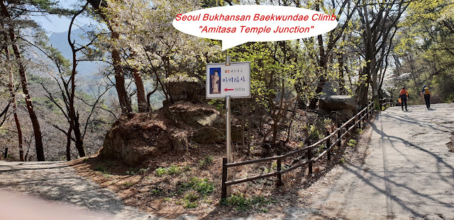
disrupter sometimes. You could find sign board saying Amitasa temple, 500m from
main road. I was wondering whether or not I should visit Amitasa since round distance
1 km and spending at least half an hour. Photo of Big Buda Statue at the sign
board was attracting me to move forward naturally and smoothly since I am personally
interested in outdoor Buda Statue, features normally different from indoor Buda
Statue. Indoor Buda Statue is normally almost same form and features at
everywhere but outdoor Statue is different not only from the indoor but also
from each other. Their features are to vary depend on each one which some time
hard to interpret like smile or laugh or dignity and so on. That is why I like
to see and check outdoor Buda Statue. I was disappointed when I see this
outdoor Buda since features almost same as normal Buda Statue as indoor Buda
features and immediately turn back to main road, losing about 30 minutes and no
return against this effort. You could see this outdoor Buda at photo. When I
join at main road after Amitasa half an hour, I met Landmark saying BWD 2.6km
at left direction- hard course and the other 4.1km –easy course. I took left
hard course because more than 1 km shorter. When walked at left, I met soon
stone pass for climbing, no more walking road and found 1.35km to Baewunbong
Amun after 20 minutes climbing. I keep walking on stone or rock pass after about
15 minutes climbing and met landmark saying BWD 1.6km. When I climbed further
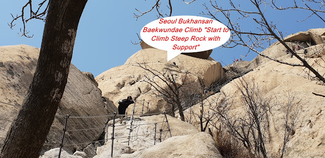
10 minutes, I saw BWD to 1.3km. I should sometimes climb on rock with steel
wire rope support after this landmark and continue about 20 minutes and found
break area where you find landmark saying BWD 800m only. But this 800m would be
provably highlighted at today’s course, so steep and hard and difficult. I took
a short break and prepare for this highlight and keep and move on rocky and
sharp and steep rocky hill through rocky pass, sometime hard to see where
correct pass on rock spread. I spent about 45 minutes climbing and move up only
400 m landmark and start to climb through comparably easy stairs from there and
met BWD Amun (entrance) after 2 to 3 minutes walking on the stairs. There was
landmark at the Amun where I would climb down to Uiedong, opposite direction
from climbing from Bukhansansung Information after BWD Summit. I should climb
on granite steep rock under steel wire support from the Amun and touch down BWD
Summit after 40 minutes so hard endeavor climbing on the rock and took a nice
photo of neighboring peak, Insubong (810.5m altitude) and Makyungdae (799.5m
altitude) where unfortunately not allowed to climb. We used to call three
peaks, BWD, Makyungdae and Insubong as a triangle mountain since these three
peaks are making triangle. You can see relevant photo for these peaks. BWD
summit area is too small to say long, 2 square meter to stay long since there
are many people climbing. I started to way down from the BWD summit though the
same route up to Amun Junction about 20 minutes and turned left at the Amun
Junction and keep climbing down though rock pass sometimes under steel wire
rope support and reached Baewun Sanjang- snack shop and rest after 1 hour down
from Amun. I climbed down to Uiedong direction along with valley stream from
the Baewun Sanjang sometime under steel rope support and found Save Post saying
1.5km to Baekwundae Information Center after 10 minutes down. Thereafter you
could meet easy walking stairs and continue to climbing down about 20 minutes and
met Bukhansan Insu Shelter as see at Photo, You could meet landmark saying only
700m to BWD Information Center after 10 minutes walking down. You could meet
BWD Information Center 20 minutes walking down where Doseonsa Junction and
1.7km to Uie Ranger Station. It is easy and convenient walking road which
bigger transportation could move on paved way like you see t relevant photo.
When you walk down on the paved way, you would meet guide landmark saying cross
the road and walking on the other side bottom lower hill and keep following
this pass for about 40 minutes, mainly walking on stair deck and should meet
Uie Ranger Station as see at the photo. As see at the photo Map from Uie Ranger
Station to Bukhansan Uie Station, it is 637m and about 20 minutes walking and
join to Bukhansan Uie Subway Line where you can conveniently connect e everywhere
in Seoul.


댓글 없음:
댓글 쓰기