1.
Date and Time : July 08, 2018. 08:00~12:30 (4 hours and 30 minutes including
break one hour).
2.
Location : Hongcheun District at Gangwon
Province in Korea.
3. Distance and Course : About 11.33 km.
Course is to start Gongjaksan Parking Lot => KNPA Recreation Forest => Junction
at Ridge => Gongjaksan Summit (887m Altitude) => Gongjaksan Recreation
Forest Lodging => Back to Gongjaksan Parking Lot.
4. Access :
There
are various ways to the Dong Seoul Bus Terminal where you could use subway or
bus or taxis depend on your situation. People are usually to use subway line 2
getting off at Ganbyeon Station and changing to Dong Seoul Bus Terminal taking 1
minute for 81m distance. You could take intercity bus bound for Hongcheun taking
about one hour and 50 minutes, nonstop. As soon as you arrive at the Hongcheun,
you should arrange local taxi to Gongjaksan Parking Lot at Nocheonri taking provably half an hour. Please refer to
the map of “Transportation from Dong Seoul Bus Terminal to Hongcheun Bus
Terminal”. There is no local public transportation from Hongcheun Bus Terminal
to Gongjaksan at Nocheonri. You should take a local taxi at Hongcheun Bus
Terminal which fare would be settled through negotiation. I estimate total transportation
time from the Dong Seoul Bus Terminal to Cheoljeung Bus Stop about 6 hours for
round trip. But you would reduce this transportation time to 4 hours for round
trip in case you use private car or rent car which you could save two hours for
the transportation.
4.
Overall
Remarks.
Gongjaksan is located between Dong Myeun and
Hwacheon Myeun which looks like shape of peacock spreading out her wing and
which remind one of beautiful oriental painting for rock peak and old pine
trees, going well together. It is known as the best scenery and hiking course
about 8 km from Sootasa Temple to Nocheonri locating at ridge for about 6 km
from the summit at South West. Many people come to this valley for healing at nature
at summer vacation season. There are many strange shaped and fantastic rock and
unpolluted deep forest harmonizing together with valley and stream. It is reputed as beautiful and attractive
azalea blossom in spring and spectacular colorful leaves in autumn like yellow
or brown or pink and so on.
It is transferred and known from old days as spiritual energy at
the mountain if mountain resemble to shape of animal. For example, Yeongchuisan
resembles to Lion, Seoraksan to crane and Gongjaksan to crane. Therefore one of
famous month, Jajangheulsa appointed Gongjaksan Mountain as one of spiritual
energy and buried true Buddha Sari somewhere at the Gongjaksan. As you move upstream
of Geuneopcheun river which is flowing down to Hongcheunkang River and see the
mountain at that position, you could obviously see resemble mountain shape to bird
head and could also look like the shape of crane opening both side wing
spreading to Naesampori and Eungbongsan Boundary. This mountain crane is stretching
her backbone and tail to Hongcheun River as look as through ridge line of the
Gongjaksan Mountain. You could take a look more highlight of Gongjaksan Hiking which I recorded at the mountain climb. https://www.youtube.com/watch?v=unWSXgcxSTk&feature=youtu.be
5.
Detailed
Course Information
As arrived at Gongjaksan Parking Lot, I have checked
Hiking Course Introduction just side of Gongjak Road and decided to which
course I should take today and selected Uphill through Gongjaksan Recreation
Forest and downhill through Course 4 as introduced at the “Gongjaksan Hiking
Course”. As soon as I looked around the parking Lot, I crossed the Gongjak Road
and took a look beautiful and quite natural Nocheon Reservoir going well
together with both side green valley. I walked to Junction where I could start
to move up to Gongjaksan Summit through the Nocheonri Village, small and quiet
and unpolluted country style and walking on easy and wide passenger car road for
about half an hour from the starting and reached KNPA Recreation Forest where I
found very cute green pond at right side of the road. When I kept walking on
the same easy road for about 5 minutes more, I reached end of this easy road
and entered into small path at bushed stream and hardly tried to climb up the stream
and bush road for less than an hour and found Junction landmark stating as 680m
to the Summit and the other 6.34km to Sootasa Temple. I turned right and straightly
climbed up the summit hill. As walked up the steep summit hill road and hardly passed
narrow and scared rock path for about one hour, I found next junction mark
saying 120m to the Summit. I took a short break there and continued to climb
the summit hill for about 10 minutes and finally touched down Gongjaksan
Summit-887 m altitude and took a nice photo and video around the Summit for a
while. I checked direction for downhill through the other way, Course 4 and
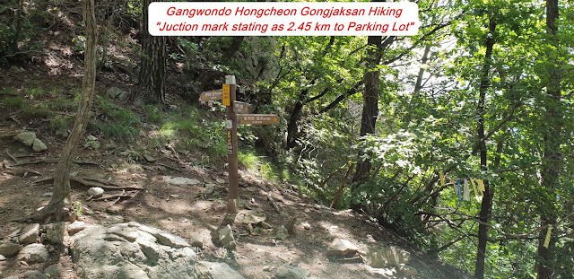
walked won for about 15 minutes and reached junction landmark stating as 2,45km
to Gongjaksan Parking Lot and the other to Gongjakheon. I took a course to
2.45km to the Parking Lot and turned right at the junction and kept walking
down through this Course 4. When I tried to make downhill this very sloped hill
road for about one hour, I met next landmark saying as 1.07km to the Parking
Lot. I kept walking down through oak tree forest, tamarack forest and crossing
the stream for about 40 minutes and reached junction landmark stating as 350m
to the Parking Lot. I turned right at the Junction and kept walking down
through easy and wide road for about a quarter minutes and eventually returned
to Gongjaksan Parking Lot after about two downhill from the summit.


댓글 없음:
댓글 쓰기