1.
Date and Time : Oct 25, 2018 08:00~15:00 (7
hours including one hour break).
2.
Location: Mungyeong-Town,
Mungyeong-City, Gyeongsangbuk-Provice
3. Distance and Course : About 16.23km.
Course is to start at Munkyeong Saejae Parking Lot No. 1 => Jeil Gwanmun Junction
(First Entrance Gate) => Yeogung Pokpo (Water Fall)=> Heguksa Temple
=> Daeguelteo (Palace Site) => Juheulsan Mountain Summit (1076m Altitude)
=> Back to the Munkyeong Saejae Parking Lot No. 1 through the Same Ascending
Course. Please refer to https://www.youtube.com/watch?v=epOJCavujXM&t=5s

4. Access :
There
is several ways to connect “Seoul Express Bus Terminal (”connecting at subway
lines No. 3, 7 and 9). Please walk to Central Bus Terminal from the Subway
Station taking 5 minutes where you should get on Express Bus bound for Jeomchon
City, non-stop and taking 2 hours and 40 minutes. When you get off at the Jeomchon
Intercity Bus Terminal, please walk to Home plus Bus Stop taking 2 minute for 171m.
You could get on local bus bound for Munkyeong Saejae and get off at Bus Stop-Munkyeong
Saejae Provincial Park taking 1 hour and
14 minutes for 31 bus stop passing. You could walk to Munkyeong SAEJAE Parking Lot
No. 1 taking 2 minutes for 104m. Please refer more details to the “Transportation
from Seoul Central City Bus Terminal to Munkyeong Saejae Parking Lot No. 1”. You
could simply take reverse course on your way back home. I could estimate total transportation
is about 3 hours and 30 minutes including waiting times for one way which comes
total 7 hours for round trip. But you would reduce this
transportation time to 5 hours for round trip in case you use private car or
rent car which you could save two hours for the transportation.
5.
Overall
Remarks.
Baekdu Daegan Mountain System makes Jungnyeong
(Ridge) after passing through Sobaeksan (Mt.). And while passing by Joryeongsan
(Mt.) via Dosolbong (Peak), Hwangjangsan (Mt.), Munsubong (Peak) and Daemisan
(Mt.), it makes Mungyeongsaejae (Ridge) between Juheulsan (Mt.) and
Joryeongsan, and then locates venerable Mungyeonggwanmun (Gate). A tale says 'when Juheulsan rose high, it would set up the capital at its foot, but seeing Samgaksan (Mt.) in Seoul which had already risen ahead, it sat down with its back against it. The high rising physical aspect of Juheulsan is admirable and fragrance of long history emits in every valley. There are four splendid hike trails well prepared. It is a thesaurus of wild flowers and was also the guardian mountain of Mungyeonghyeon in the Joseon dynasty.
6.
Detailed
Course Information
I was
stayed at Suanbo Town which could reach to Munkyeong Saejae less than an hour
and came over to Saejae Parking Lot No. 1 slightly before 8 o’clock. I thought
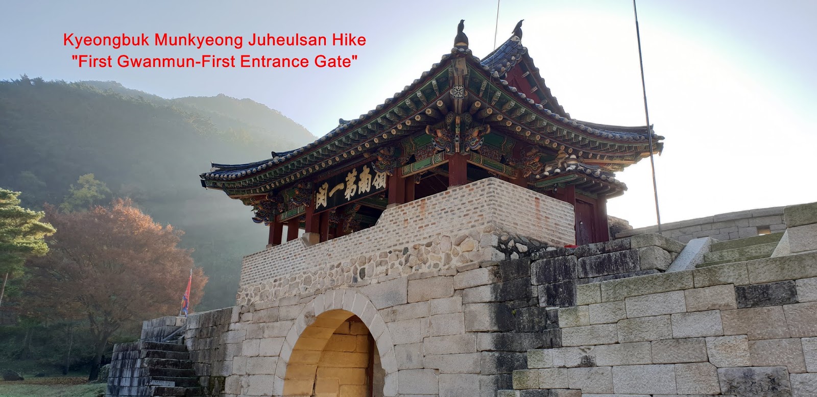
this Parking Lot No. 1 would be closest to Jeil Gwanmun (First Entrance Gate).
But these was Parking Lot No. 4 was just above which was something closer to
Jeil Gwanmun, say about 200m. Therefore please car the car to the Parking Lot
No. 4 if anybody intend to park the car more closely to the Jeil Gwanmun. I
walked on Saejae village street heading to Saejae Gwanmun for about five
minutes as soon as parked the car at Parking Lot No. 1 and found sign board
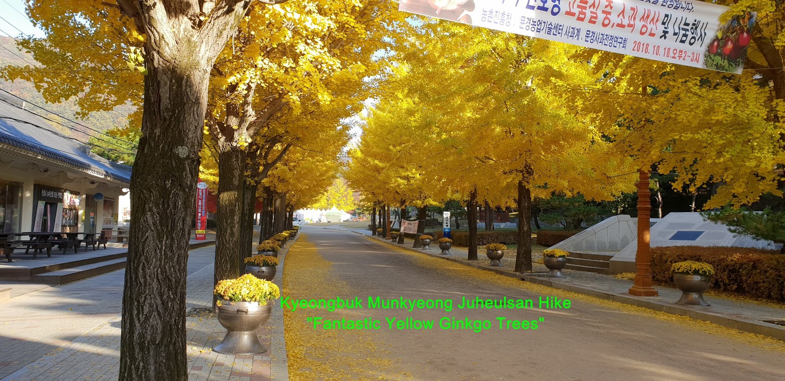
introducing Munkyeong Apple Festival from Oct 13 through 28, 2018. I saw so beautiful
and fantastic view of yellow ginkgo trees on the street and took it to photo as
attached. I kept walking the street for about 10 minutes from the Apple
Festival Sign Board and found extraordinary colorful and beautiful scenery at
stream besides the street and continuously walking for 10 more minutes and
reached junction at jeil Gwanmun where I could take Juheulsan Summit either 4.5km
to Juheulsan Summit and 800m Yeogung Pokpo (Water Fall) at right or to Jeie
Gwanmun (Second Entrance Gate) at straight. I turned right and kept walking on
unpaved hiking course road along with stream at left for about 20 minutes and
met next junction mark stating the one at right as 300m to Yeogung Pokpo, 1.2km
to Heguksa Temple and 3.8km to the Summit and the other at left as 900m to
Heguksa Temple and 3.5km to the Summit. I took a right hike course and carried
on walking on the road along with stream and saw natural colorful beauty at the
valley which well harmonized with different color leaves by different species
trees like yellow, yellow green, red, pink and so on. I through these so
beautiful leaves would soon drop to the ground for the winter preparation which
would be closer to human life cycle since human cycled as peak vigorous younger
period at 20 to 30 years (Dark Green Leaves at the tree), matured period at 40
to 50 years (Colorful Leaves at the tree) and closing preparation period 60 to
70 years (dried and wrapped or twisted brown leaves). Anyhow I Kept walking on somewhat
steep concrete paved road and sometime crossed over the bridge and slopped wood
stairs for a quarter minutes and reached landmark near to Yeogung Pokpo (Water
Fall) at elevation 340m altitude stating as 1km to Heguksa Temple and 3.6km to
the Summit. When I walked on somewhat slopped rocky road for a while, I saw
nice Yeogung Pokpo, about 10m high and looked around and continuously ascending
through steeper uphill rocky road and wood stairs for about half an hour and
reached junction between Heguksa temple and Summit direction. I saw
exceptionally wonderful and beautiful scenery at rock valley and took a photo
on the way to this junction. I turned straightly right to the Summit way and
made my mind I would drop the Heguksa temple on the way down after I touch down
the Summit. I felt it became harder and harder depend on higher and higher and
steeper and steeper time by time. As I walked up through tis hard road for about
half an hour, I found landmark stating as 1.54km to the Summit. I kept climbing
on these tougher and harder rocky road for about less than an hour and met
Daeguelteo where there was much cooled natural mineral water spring as well as
rest and break area. I drunk such cooled mineral water and took a short break
and chatted with other climbers for short while. I started to climb so highly steeper
stairs which was longest wood stairs and walked up for about half an hour and reached
ridge areas as soon as finished the wood stairs. I turned right at the ridge
junction and continuously walking on the ridge road and passing wood deck road and
connecting last wood stairs for about 20 minutes and met junction at the wood
stairs stating as 50m to the Summit at right and 1.2km to Youngbong Peak at
left. I turned right and kept waking up the stairs for about 5 minutes and
finally touched down the Juheulsan Summit; 1076m altitude and looked around the
Summit for a while and started to descend through the same road that I took
this morning. When I walked down through the stairs for about 5 minutes, I
found junction mark stating as Jeie Gwanmun (Second Entrance Gate at right and
Jeil Gwanmun (First Entrance Gate) at straight. I took a straight road and
continued to downhill for about one hour and reached Heguksa temple which I
missed on the way ascending this morning and dropped the temple and learned
this was small, cute, neat and clam temple sitting at optimistic location at
the valley. I somewhat hardly walked on the temple and looked down gorgeous valley
with various colorful pictures at main temple hall as see at the photo. I kept
walking down through the same course road for about one and half an hour from
the Heguksa temple and back to the Saejae Parking Lot No. 1.


댓글 없음:
댓글 쓰기