1.
1. Date and Time : Oct 15, 2018 08:30~14:00 (5
hours and 30 minutes including one hour break).
2.
2. Location : Nonsan-si, Gongju-si,
Chungcheongnam-do Province and Daejeon Metropolitan City
3. 3. Distance and Course : About 18.45km.
Course is to start at Donghaksa Temple Parking Lot => Donghaksa Main Gate
=> Donghaksa Temple => Eunseon Water Fall => Gyeryeongsan Gwaneumbong Summit
(766m Altitude) => Back to the Donghaksa Temple Parking Lot through the Same
Ascending Course. Please refer to https://www.youtube.com/watch?v=-bMvHaF7198

4. 4. Access :
There
is several ways to connect “Seoul Express Bus Terminal (”connecting at subway
lines No. 3, 7 and 9). Please walk to Central Bus Terminal from the Subway
Station taking 5 minutes where you should get on Express Bus bound for Sejeong
City, non-stop and taking 1 hours and 36 minutes. When you get off at the Sejeong
Express Bus Terminal, please walk to Sejeong Intercity Bus Terminal taking 3
minutes for 168m. You could get on express Bus No 990 and get off at Banseoyeok
Bus Stop taking 17 minutes for one stop. Please walk other Banseoyeok Bus Stop
taking 1 minute for 16m and get on local bus No 303 and get off at Donghaksa
Bus Stop taking 52 minutes for 26 bus stop passing. Please refer more details
to the “Transportation from Seoul Central Bus Terminal to Donghaksa”. You could
simply take reverse course on your way back home. I could estimate total transportation
is about 3 hour plus 30 minutes including waiting times for one way which comes
total 7 hours for round trip. But you would reduce this
transportation time to 6 hours for round trip in case you use private car or
rent car which you could save one hour for the transportation.
5.
5. Overall
Remarks.
It's located at the end of Geumnam Jeongmaek among
Baekdu Daegan Mountain System. In 1968 it was designated as a second national
park in Korea. At 845.1m above sea level, this independent noted mountain
displays graceful features. It is called Gyeryongsan because it looks like a
"dragon with a crest". According to the administrative division, It is mostly located in Gongju-si (city), Chungcheongnam-do and parts of it covers Daejeon Metropolitan City and Nonsan-si (city). Gyeryongsan is a noted mountain the nation paid attention to because a national ancestral sacrifice had been performed here.
It was well-known as Gyeryong or Gyerim to the Tang dynasty across the sea in the era of the Baekje dynasty. It is the monadnock mountain, formed between Charyeong and Noryeong Mountain Rages. The Gunbong (Peak), formed by upheaval of quartz porphyry, is magnificent
6.
6. Detailed
Course Information
I came
over to Donghaksa Temple Parking Lot early in the morning less than an hour
from Gongju Forest Town, lodging where I could start to ascend over the Gyeryeongsan
Mountain this morning. As I parked the car at Donghaksa Parking Lot, they
requested me to pay only KRW 4,000- per car and no credit card. I remarked “There
is only one reason why they pay in cash only”. But I could not have any other
option since this parking lot is only one parking lot at that area. Therefore I
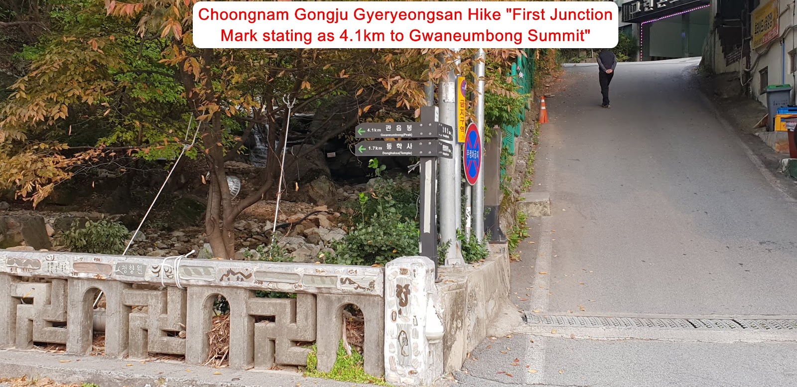
paid in cash as they asked. I walked on paved road for about 5 minutes where
there are many shops and/or restaurants on the way at left and right and found
first landmark at the bridge stating as 4.1km to Gwaneumbong Summit and 1.7km
to Donghaksa Temple. As I walked on the same road for about 5 minutes, I met
ticket booth collecting entrance fee, adult KRW 2,000/head, teenage KRW 700/head
and children KRW 400.head. I just passed the ticket booth due to senior, above
65 years old. I walked on paved good and easy walking road along with fresh and
unpolluted Donghak Valley for about 10 minutes from previous landmark and
reached Donghaksa Temple main gate and faced elegant great Donghaksa Main Gate.
I saw one family walked on the same way heading to Donghaksa temple and looks
so nice and peaceful and going well together with around Donghak Valley. I
found Gyeryeongsan Hike Course Map right after the Main Gate and checked
possible course and choose the best way that I could comfortably and conveniently
cover today and selected shortest course as illustrated at the Course Map as attached.
I kept walking on the same road for about 15 minutes and met junction at the
Donghak Valley stating as 400m to the Donghaksa Temple through old walking road
and 2.8km to Gwaneumbong Summit. So I took a old walking road at left and going
on the way. When I walked on the road, I saw neat and beautiful Octagon Pavilion
at the Valley Stream at left which was going so well together with nature view
at the valley. When I walked on this old road for about 15 minutes, I reached
Donghaksa Temple and came to see the Main Temple Hall and three story stone
pagoda at temple field in front of the main hall. I closely approached to
Samsebulsang at the main hall for about 10 minutes which means three Buddha (Seokgamoni
Buddha, Yaksayeorae Buddha and Amitabul Buddha) and came over to Hiking area
where I should start to ascend slopped stone stairs road and found landmark
saying as 2.1km to the Summit. I waked through wood deck and bridge road and continuously
walking so steep wood blog stair zigzag road for about half an hour and reached
Eunseon Water Fall area and appreciated so nice and cool nature view. But It
was quit unlucky since dust level was becoming high and high time by time. Therefore
I could not clear picture of colorful scenery around water fall as well as
valley. When I walked above the Eunseon
Water Fall through course road, I found next landmark stating as 1 km to the
Summit and kept walking on steep stony road for sometimes and found so steeper
and harsh stony road after half an hour more from the previous landmark. I
struggled to ascend this so hard slopped road for about 10 minutes and reached steep
wood blog stair road which was a bit better than before. I walked up on the
stair road for about 15 minutes and found landmark at the hill figuring as only
100m to the Summit at right. I took a short break and continuously walking up
the steeper hill for less than 10 minutes and finally touched down the 766m
altitude Gwaneumbong Summit. Dust level was becoming worse so that I could not
see around nice picture around the Summit and took a photo for Samheongje Bong
Peak which was not far from the Summit. I took lunch break at the Octagon
Pavilion on top and checked downhill course and confirmed descending landmark
and walking down through the descending arrow at the landmark. I passed Eunseon
Water Fall again on the way down and took one more shot under more close view.
As I came down some minutes, I saw Ssalgaebong Gorge on the peak at right and
took a nice view shot as long as I could do under dust level high. Thereafter I
eventually back to the Parking Plot after 1 hour and 30 minutes descending from
the Summit.


.
댓글 없음:
댓글 쓰기