1.
1. Date and Time : Oct 10, 2018 09:00~15:00 (6
hours including one hour break).
2.
2. Location :. Goesan-District, Chungcheongbuk Province and
Mungyeong-City, Gyeongsangbuk-Province.
3. 3. Distance and Course : About 11.23km.
Course is to start at Daeyasan Restaurant Parking Lot => Yongchu Water Fall
=> Wolryeongdae Junction => Piagol Valley => Daeyasan Summit (930.7m Altitude) => Back to the Daeyasan
Restaurant Parking Lot through the Same Ascending Course. Please refer to https://www.youtube.com/watch?v=o_Unxh61gNA&t=103s

4. 4. Access :
There
is several ways to connect “Seoul Express Bus Terminal (”connecting at subway
lines No. 3, 7 and 9) where you should get on Intercity bus line bound for Jeomchon
Inter City Bus Terminal, non-stop and taking two hours and 10 minutes. When you
get off at the Jeomchon Terminal, you
should walk to Home Plus Bus Stop taking 3 minutes for 171m. Please get on local
bus bound for Gaeun and get off at Byeobawei Bus Stop taking 1 hour and 42
minutes for 48 times bus stop passing. You should walk as soon as get off
taking 10 minutes for 653m. Please refer more details to the “Transportation
from Seoul Express Bus Terminal to Daeyasan Restaurant”. You could simply take
reverse course on your way back home. I could estimate total transportation is
about 4 hour plus 30 minutes (waiting interval time) for one way which comes
total 9 hours for round trip. But you would reduce this
transportation time to 7 hours for round trip in case you use private car or
rent car which you could save two hours for the transportation.
5.
5. Overall
Remarks.
Daeyasan
covers parts of Cheongcheon-Town, Goesan-District, Chungcheongbuk-Province and
Gaeun-District, Mungyeong-City, Gyeongsangbuk-province. It's 931m high above
sea level and belongs to the Songnisan national park, past Baekhwasan (Mt.) and
Huiyangsan (Mt.) and before reaching Songnisan (Mt.) along Baekdu Daegan
Mountain Stream. There are beautiful valleys such as Seonyudong Valley, Yongchu
Valley, toward Chungcheongbuk-Province, and Hwayang Valley toward
Gyeongsangbuk-Province. It is also called Daehasan, Daehwasan, Daesan,
Sangdaesan etc. but according to Mungyeonghyeonji (old document) published in 1789,
it's written as Daeyasan. Hiking generally starts from Beolbawi Rock in Gaeun-Town,
past Mungyeong City) over Ihwaryeong Ridge.Walking on the newly-built road along the valley, you can look up a monument marked by extraordinary rocks. This is Yongchu Valley, with a stone monument carved as Mungyeongpalgyeong (8 views of Mungyeong) at the entrance. Considered the best among spectacles of Yongchu Valley, Yongchu Water Fall is composed of 3 tiers and forms a unique heart shaped tub in the center of whitish gray granite.
On both sides of Yongchu there are rocks engraved in intaglio as Sesimdae, Hwacheongdam, Okhadae, Yeongchaseok etc.
Ascending about 20 minutes from Yongchu leads you to Woryeongdae where you can see moonlight reflected on rocks and valleys. This is the point where two streams from Daraegol Valley and Piagol Valley join together. Along the valley it takes about 2 hours to reach the top. Around the summit slopes are steep and trails are rugged so you'll have to clamber up the rocks and plow your way through the brush. On the top there is a rock of about 10 pyeong (33.05m2) where stands a wooden signpost with the name of the mountain on it and you can outlook a cluster of mountain peaks. From the summit at the center, the north is Bullanchijae Ridge and the south is Miljae Ridge.
Descending the mountain could be to Bullanchijae via Chotdaebong Peak but the trail is rugged and it takes about 7 hours in total along this route. So most people descend toward Miljae because it takes about 5 hours along the south ridge. Miljae is a pass that borders Gyeongsangbuk-do with Chungcheongbuk-do. Take an express bus from downtown of Mungyeong to Gaeun- Town and transfer to an urban bus bound for Beolbawi Rock. There is a birth place of Yi Gangnyeon, a general of loyal army in Wanjang-ri, Gaeun-Town close to the mountain.
6.
6. Detailed
Course Information
I have
arranged to stay somewhere middle of three mountains, Huiyangsan, Doraksan and
Daeyasan and selected Choongju Suanbo area which I could connect all these mountains
within less than 2 hours. I booked Suanbo Saipan Oncheon Hotel (SSO) with lower
price per day, KRW 45,000-/Day including continental breakfast and paid three nights for 135,000- which was clean
and kind service taking into account performance against price. There was no major problem, even poor sound proof insulation between room and room, But I climbed every day almost 1,000 m Altitude
Mountains which are included in NPS recommended Korea 100th mountains. As soon as I finished hot spring bath and dinner, I could easily dumped to deep sleep, no problem. I believe working people at the hotel should be qualified for business communication in English. That was the reason why I could
come to Daeyasan Parking Lot early in the morning, 09:00 hours. As I parked the
car at the parking lot, I thought there would be someone requesting me to pay
the parking fee but nobody. I interpreted somebody might collect the parking
fee when I was coming back after the mountain hike. I came to hike information
area after the park where I could see landmark stating as 4.5km to the Summit
and started to move to uphill along with Yongchu Valley and reached Hike Course
Map after about 10 minutes walking on paved road which was illustrating course
1 indicating as 4km at left and Corse 2 indicating as 4.2km to the Summit. I
found the landmark stating as the same as above distance, 4.2km to summit. I
kept walking up the hiking course road for 15 minutes and reached Yongchu which
was two stepped water fall and looks mysterious shaped fall and pond under the
fall coloring light blue and green as shown at the photo. I carried on walking
on the hike road and found nice red color maple tree well matching with around
other green trees as you see at the photo. I continued to walk on the valley
rocky or stony road and sometimes wood deck and stair road for about a quarter minutes
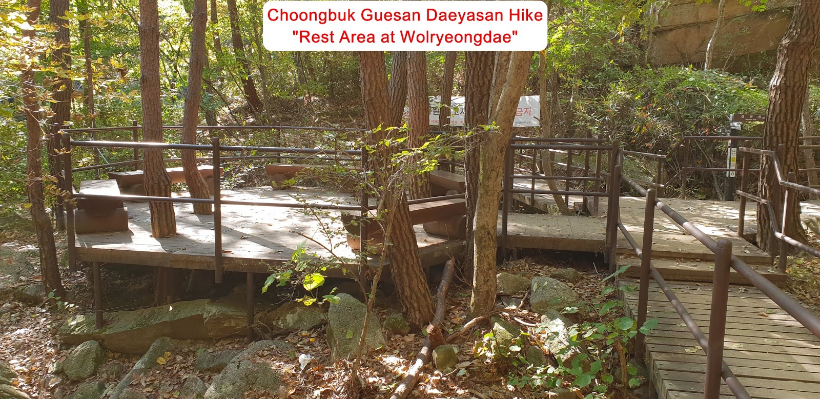
from the Yongchu Water Fall and reached Wolryeongdae Observation Junction where
I could take either way 1.9km to the
Summit straight or 1.9km to the Milje Hill. But I took a straight course. There
were some wood stool which climber could take appropriate break on the way up
as see at the photo. As explained at overall remarks, Wolryeongdae Observation
was good area observing rising moon at night. I kept walking uphill through the
stony or rocky course road following valley stream without break for about 40
minutes and reached next landmark stating as 1.2km to the Summit. There were
steeper rocky and stony uphill road after the previous landmark and sometimes passed
deeply inclined zigzag stair road. I continuously ascended this road and found so
pretty beautiful and colorful maple trees between stair roads and recorded at
the photo as see and met last landmark saying as only 300m to the Summit which
I could see the preview of Daeyasan Summit. I finally touched down Daeyasan
Summit Monument; 930.7m altitude after 2 hours and 30 minutes uphill struggling
endeavor via last three way junction stating 1 km to Milje Hill at left and the
Summit just right. I tried to look around view of Surround Mountains at the
Summit and took it to camera as see t the photo and started to descend after
lunch break near to the Summit and back to the Daeyasan Restaurant Parking Lot after
2 hours from the Summit.


댓글 없음:
댓글 쓰기