1.
Date and Time : June 18, 2018 09:00~16:30 (7
hours 30 minutes including break one and half an hour).
2.
Location : Jecheon District at Choongbook Province
in Korea.
3. Distance and Course : About 14.46km.
Course is to start at Deokjusa Parking Lot => Maaebulsang => Songge
Samgeuri => Shilok Samgeuri = Youngbong Summit (1097m altitude) => Back
to at Sanghakdong Parking Lot though the same route.
4. Access :
There is several ways to connect “Dong Seoul Bus Terminal (” by means of subway lines No. 2 at Gangbyun Station) where you should get on Intercity bus line bound for Deokjusa, non-stop and taking three hours. When you get off at the Deokjusa Bus Stop, you should walk to Deokjusa information Center taking about 30 minutes for about 990m distance. Please refer more details to the “Transportation from Dong Seoul Bus Terminal to Jecheon Deokjusa”. You could simply take reverse course on your way back home. I could estimate total transportation is about three hour and thirty minutes for one way which comes total 7 hours for round trip. But you would reduce this transportation time to 5 hours for round trip in case you use private car or rent car which you could save two hours for the transportation.
5.
Overall
Remarks.
5-1) Wolaksan Mountain is located at Jecheon
District in Choongcheong Bukdo Province in Korea which is 1,097m altitude
highest mountain in the province. There are several evidenced sites remaining
like Deokjusa Temple, Deokjusansung
(Fort Castle), Wolkwangsa, Woakgeung, Wolakshinsa. There are three major ridges
from Wolaksan Mountain which is at North West extending to Choongju lake, which
is at North extending at Shirumi to Kwangcheun and which is a major ridge at
South extending to boundary to Kyungsang Bukdo. There are two major rivers
originated from Wolaksan, the one Kwangcheon at East and the other Dalcheon at
West which was joined at Hancheonri before and flowed to Han River. But these
rivers are nowadays joined at Choongju Lake and directly flowing to Han River.
There are eight best sceneries at Wolaksan like Wolkwang Water Fall,
Mangpockdae, Haksodae, Sookyungdae, Jayeondae and Suryeomdae. But it is the
best scenery at Wolaksan Summit looking around surrounding mountain scenery at
Wolaksan Summit.
5-2)
Wolaksan Mountain had been originally named as Wolhyeongsan which means the
best scenery that shows spectacular picture rising moon through Wolaksan.
Thereafter its name was changed at Koryeo Dynasty as Waraksan which was storied;
King of Wang Geon, founder of Koryeo Dynasty was choosing for new capital
between Songhaksan in Gaesung and Wolhyeongsan in middle of country and finally
selected Songhaksan in Gaesung. The people living at Wolaksan area was so
disappointed for losing capital nomination and changed Wolhyeongsan to Wolaksan
which means Warak Disappointment. Warak means in Korean as suddenly and
unexpectedly fall down at a time.
5-3)
There is another old love story between Maeitaeja who made Mireukbul at Deokjusa
and left for Geumgangsan Mountain and after his left, his younger sister,
Deokju Prince who made Mauibul at Wolaksan.
6.
Detailed
Course Information
There
is KNPS Deokju Information Center near to Deokjusa Temple where I could start
to uphill the Wolaksan Mountain. When walked few steps, I saw first landmark
stating as 4.9km to Wolaksan Summit and continued to walk on wood deck road
besides the valley stream. I reached 2nd landmark saying as 4.4km to
the Summit after a quarter minutes walking through somewhat easy walking road
and crossing over the bridge. As I walked on similar easy walking road for 20
minutes more from previous landmark, I found 3rd landmark saying as
3.9km to the Summit. But road becomes changed to harder and steeper hill road
after the 3rd landmark. When I climbed on somewhat sloped hill and
stairs for 20 minutes more, I reached 4th landmark as 3.4km to the
Summit where Maaebulsang Sculpture is close by the landmark and carved on Rock.
I carefully reviewed Buddha’s features and somewhat difficult which features
Buddha took like smile or laugh or angry or elegant. It looks Buddha might
feature as some elegant and dignity. As I climbed the hill through so sharply
sloped wood stairs and hard rock path, steeped stone stairs and steel stairs
for about 50 minutes, I hardly reached 5th landmark saying as 2.9km
to the Summit. There was unique and beautiful old pine tree growing at the
middle of nearly vertical cliff as see at the photo attached. Wolaksan Hill
became rougher and tougher in accordance to higher and higher after the Maaebul
Sculpture. I had to climb zigzag stairs so sharply inclined and also passing through
rocky narrow path for about some more than one hour and reached 6th
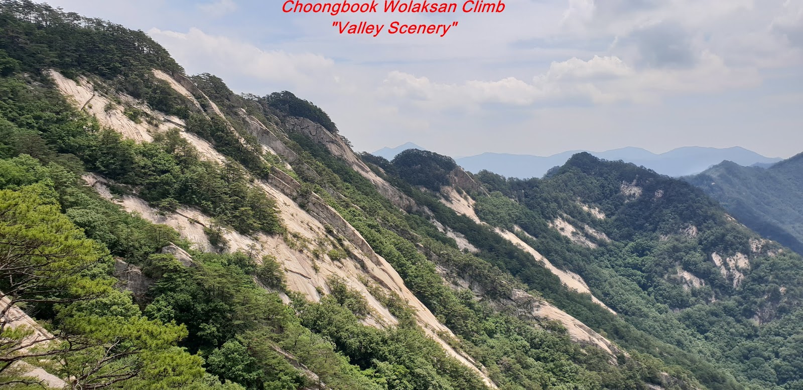
landmark saying as 2.4km to the Summit. I saw great Wolaksan Summit and
Choongju Lake during the walking from 5th landmark and 6th
landmark and nicely took a photo. I walked comparably easy walking on ridge
road through sometime oak bushes for about 10 minutes and found 7th
landmark saying as 2.2km to the Summit. When I walked about 15 minutes from
previous landmark, I reached Heliport where I could see Wolaksan Summit so
closely and clearly as see at the photo attached. I walked down on wood stairs
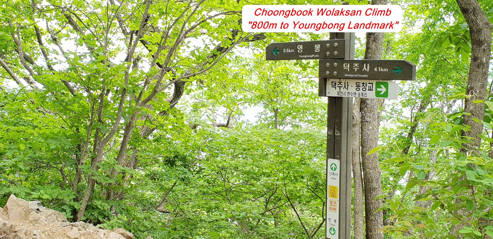
for some minutes and met 7th landmark saying as 1.5km to the Summit
standing at Songeri Junction elevating as 800m altitude. As I walked for some
minutes more, I reached 8th landmark saying as 1.2km to the Summit standing
at Mieruk Samgeuri. I continued to walk for about 10 minutes on easy ridge road
and met 9th landmark stating as 800m to the Summit at Shiloksa Samgeuri.
As see at the photo, there were very steeply sloped zigzag steel stairs which
were so hard to climb over. I hardly climbed over these stairs for about half an
hour and reached 10th landmark stating as 300m to the Summit. I finally
touched down Wolaksan Summit-1067m altitude after struggling against so steep stairs
and uphill for 15 minutes. I took a video and photo for so wonderful mountain
scenery surrounding the Wolaksan Summit. As soon as I looked around the Summit
and started to downhill through the same route as I climbed before. I saw one
more nice old pine tree standing on neighboring peak and took a photo as see at
the Photo. There was Youngbong Summit Ranger Office near to the Junction at
Songge Samgeuri. I walked downhill for about 2 hours and 30 minutes and eventually
back to Deokjusa Temple Parking Lot and took a phot for Deokjusa Main temple
and Deokjusa Bell as see at the Photo.


댓글 없음:
댓글 쓰기