Date and Time : May 23, 2018 10:00~18:00 (8 hours including break one hour).
2. Location : Pocheon at Gyeonggi Province in Korea.
3. Distance and Course : About 10.00km. Course is to start Sanjeonghosu Sangdong Parking Lot => Chaekbawi Rock => Octagonal Pavilion => Samgakbong Peak (906m Altitude) => Myeongseongsan Summit (923 m Altitude) => Jiinsa Temple => Back to Sanjeonghosu Sangdong Parking Lot.
4. Access :
There is several ways to connect “Seoul Express Bus Terminal (”connecting at subway lines No. 3, 7 and 9) where you should get on express Bus bound for Pocheon Bus Terminal, non-stop and taking one hour and 5 minutes. When you get off at the Pocheon Bus Terminal, you should walk to IBK Bus Stop taking 3 minutes for 178m and get on local bus No 138-6 and get off at Sanjeonghosu taking 1 hour and 38minutes for 54 bus stops passing. Please walk to Sanjeonghosu Sangdong Parking Lot taking 1 minute for 86m. Please refer more details at “Transportation from Seoul Express Bus Terminal to Sanjeonghosu”. Please take reverse course on your way back to home. I could roughly estimate total transportation is about three hours for one way which comes total 6 hours for round trip. But you would reduce this transportation time to 4 hours for round trip in case you use private car or rent car which you could save two hour for the transportation.
4. Overall Remarks.
In autumn, it is famous for eulalia trails. Myeongseongsan (Mt., 922.6m) is located 84km northeast from Seoul and 7km from Uncheon. It holds Sanjeonghosu (Lake) at the bottom of the mountain, providing beautiful scenery of the lake and a great hike trails.
There is a legend about the sorrow of Gungye, the founder of Taebongguk (nation). The story is hidden behind the grand Myeongseongsan (Mt.) standing firmly like a folding screen behind the lake. He was so tyrannically ruling the nation. Wang Geon, 1st King and founder of Koryeo had worked with Gungye at beginning and finally left Gungye for establishment of his own nation, Koryeo. He attacked Taebong Nation which was weaker against Wang Geon attack and finally was chasing Gungye at the Myeongseongsan and killed Gungye. But He noticed his solders let them free go everywhere and wailed with remaining solders. That is why people put name of this mountain as 'Ureumsan (Mt., means mountain of cry)' and later Myeongseongsan (Mt.), using Myeong(crying) and Seong(sound) in chinese letters. According to the legend, the mountain itself cried out for lament of lost nation together with Gungye. Or, the servants and the horses who lost their master cried out until the mountain's cry rang out. The beautiful view with flourishing eulalia has been known to hikers somehow. Since 1997, Myeongseongsan (Mt.) Eulalia Flower Festival has been held ebry year from the end of September to the beginning of October.
As the hiking trails were developed along with the tourist site of Sanjeonghosu (lake), it is regarded as the best hike trail favored by novices as well as professional hikers. Views from the top show Oseongsan (Mt.) to the north, Sanghaebong (Peak), Daeseongsan (Mt.) and Baegamsan (Mt.) to the northeast, Gwangdeoksan (Mt.) to the east, Baekwunsan (Mt.) and Gungmangbong (Peak) to the southeast
5. Detailed Course Information
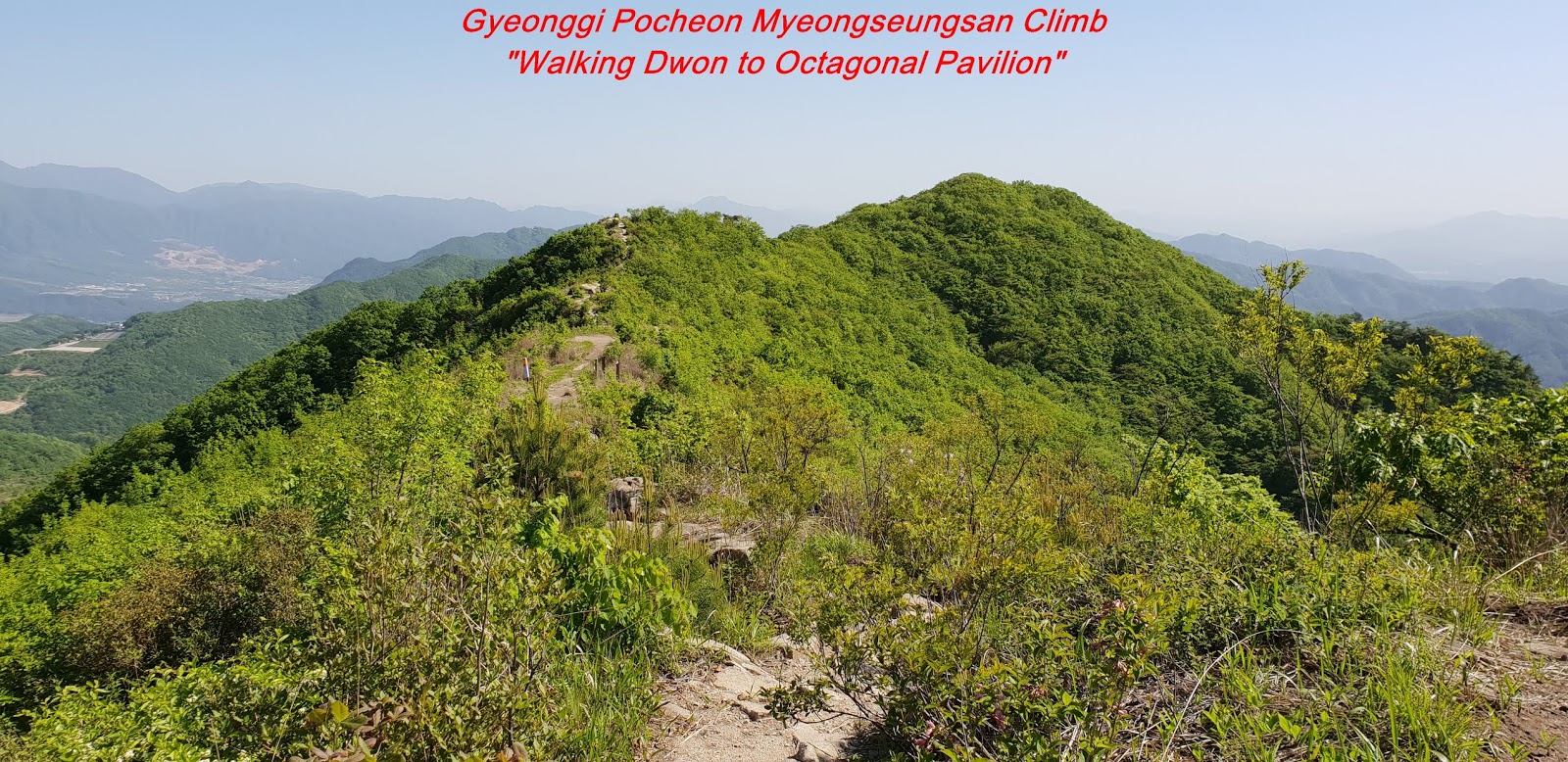
There are three hiking courses at the Myeongseongsan, first one starting at Sanjeonghosu, starting at Jiinsa Temple and last one starting at Shinahngogae. I chose first one starting at Sanjeonghosu which most people like to take for beautiful Sanjeonghosu Lake at the down view at Chaekbawi (Book Rock) and also for very widely spreading Silver Grass Field at Octagonal Pavilion. I parked the car at Sanjeonghosu Sangdong Parking Lot and moved through climb starting village for about 10 minutes and fond first Junction, the one going to Chaekbawi for 2.2km and the other going to Deungnyong Water Fall. I started waked on steep wood log stairs, sometimes through steep stony ridge road and mainly through normal ridge road for about half an hour and reached second landmark stating as 1.5km to Octagonal Pavilion. As I kept walking up through ordinary ridge road and sometimes on rocky road for about three quarter minutes, I saw landmark saying as 1.3km to octagonal Pavilion and turned right at the Landmark and walking through so steep wood stairs standing on so steep rocky hill. I could mysteriously look down beautiful open view of Sanjeonghosu Lake, nearly vertical rock mountain and remotely Myeongseongsan Summit during the climbing as you see at the photo and kept walking through the same road for about half an hour more from previous landmark and reached stating as 1 km to Octagonal Pavilion. When I passed the landmark, I saw beautiful nature view of Chaekbawi which I could figure the reason why they put Chaekbawi (Book Rock) look as opened book pages. I kept walking through steep stairs and normal ridge road for about some more 30 minutes and found Octagonal Pavilion standing near to broad Silver Grass Field via landmark saying as 700m to Octagonal Pavilion. Pocheon District has been every year holding Silver Grass Festival in late autumn. I walked up at second floor at the Pavilion and looked down to so broadly spreading the Silver Grass Field and felt sure scenery of this broad Silver Grass Field should be greatly spectacle. Relevant Picture of this festival as attached which I picked up at Web Site at the Korea Tourism Organization. I pleasantly took an enough break at the Pavilion and heading to Samgakbong Peak (Triangle Peak) though somewhat sloped ridge for about one hours and closely saw Samgakbong Peak and continuously walked for about 20 minutes more and reached Samgakbong elevating as 906m altitude as see at the Photo. I could see Myeongseongsan Summit closely at the Samgakbong Peak which looks very near. But it was not so close as looking. I kept walking up for about a quarter minutes via 300 m landmark and finally touched down Myeongseongsan Summit elevating as 923 m altitude and shortly looking around. I started to walk down through the same ridge road for about one hour and reached Junction, the one going down to Sanjeonghosu lake and the other going down to Jiinsa Temple for 1.65km and took the latter road and continued to down road though similar road for some more than half an hour and saw landmark stating as 200m to Jiinsa temple via 1.4km to Jiinsa Temple Landmark. As I came down through the similar rocky road and ordinary road for about one more half an hour, I reached Jiinsa Temple elegantly standing in front of Myeongseongsan Mountain. I eventually returned to Sanjeonghosu Sangdong Parking Lot after about 3 hours down walking where I parked the car this morning. . 


1.
댓글 없음:
댓글 쓰기