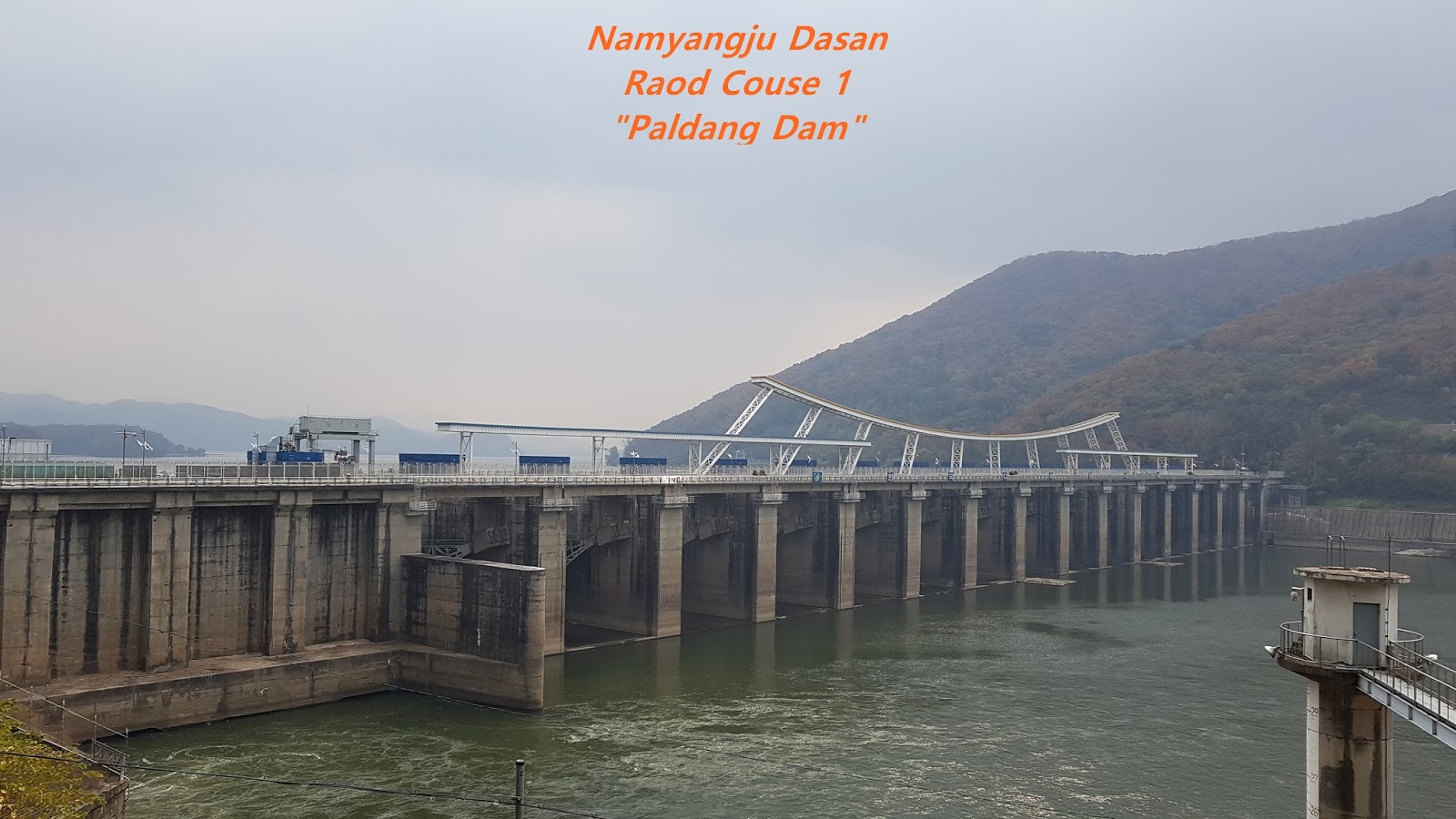
Nov 3, 2017 10:00 ~14:00 hours. Total distance is 15.43 km and taking about 6 hours. I took a mind combining Course 2 and 3 since each Course is too short to cover one day Trail, Course 2 is 3.4 km and 3 is 4.03 km. I reviewed each Course and found each Course is connected to Course 1 and there should not be any difficulty and problem in view of total distance 7.43 km and expecting time is about 4 hours. I moved to Woongilsan Train Station by car because I will start the Woongilsan Station and return to the same Station. When Left the home, it was raining and getting a bit heavier during my driving to Woongilsan. I was wondering how I will do if raining continues and heavier even after I arrive at the Station. But I checked Weather Forecast saying it is raining in the morning only and stop afternoon before I left the home and decided to believe the Forecast. When I arrive at the Woongilsan Station, it was no raining as Forecast said. I headed to the Course 3 Start straightly after arrival. It usually takes about more than 2 hours by public transportation, subway. But it took only one hour a bit more by car so that I could save more than half an hour on one way which comes round way more than one hour. I reached Course 3 as calling as "Bird Singing Road" after 20 minutes walking from the Station and found there were two different road sign which is somewhat hard to interpret these two different road sign. Therefore I decided to check the Naver Map with mobile phone showing the complete Course and moved to follow the course map walking along side Jeoahn Stream. I could not find any sign or road indication for about half an hour where to go the Course 3 and eventually found land mark Course 3 "Bird Singing Road" at the Bangah Bridge and continued to follow the small path through Saewol Bridge where Jeoahn Village 2 Assembly Hall. I turned left at junction point heading to Seonwangdang Hill where I took a so nice picture showing colorful trees, red, yellow and green as you see at the attached photo. This is a boundary between Jeoahn 1 Ri and 2 Ri. I walked Jeoahn 2 Ri so far with some effort finding road connection and finally heading to Jeoahn 1 Ri through the Hill where completely different style and atmosphere from Jeoahn 2 Ri. there were many and proper Road Sign with simple information or indication. They some times introduced not only Road Sign but also introduction of some historical story or legend at the Village. I was wondering how these two Villages are so different character and style. I continue to walk the Course with such good image and suddenly surprised to meet so rough and aggressive dogs moving around road and felt sacred when I went through the road. I therefore shouted and called dog owner for taking care the dogs. He replied "My dogs won't bite. Don't worry" I answered "Please take the dogs and hold" But he did not hold white dog slowly following and baking. I eventually and fortunately passed the dog area without any problem. I went on the Course after Jeoahn 1 Ri Village and came across Pet Training Center and thought there might be possible reason between previous Village and this Pet Center. I rejoined Course 1 after passed under the Bongahn Great Bridge and saw and met Paldang Dam where I took a so delicious, relax-able and comfortable lunch sitting near to the Dam on the rest chair that I felt at that time there is no envious thing in the world. I extended to walk to Dasan Road Course 2 calling as Dasan Road where very well going with Paldang Dam Wetland. It should make you reminded some unforgettable and memorial story when you walk the small path with reed and silver grass at village lower hill closer to Dam. This road is connected to Dasan Park at Dam where there are many artificial things for visitor's eye entertainment. But I was not so interest in such artificial things at the Park area and could not find attractive image or view at the Park, no photo at the Park. I carried on to Majae Pilgrim Area where I could see Neungnae Old Train Station when I walk over the Majae Hill and connect to the Course 1 leading to Woongilsan Train Station.
Living with Nature more closely for Limited Remaining Life Span.....
2017년 11월 17일 금요일
2017년 11월 7일 화요일
Namyangju Dasan Road Course 1 -Yangju, Korea
November 1, 2017 from 09:30 to 14:00 hours, total distance 17.9 km and taking 4 and half hours. I successfully completed Bukhansan Trail Course from 1 to 21 taking total 9 days last month and tried to find which Course is suitable and convenient for my next course and found finally Namyangju Dasan Road should be best for my next target course consisting of total distance 169.3 km with 13 different each Course, average 13 km for each. As usually done before, I came eventually down Dukso Train Station exchanging the train line two times and reached to Hankang Bike Trail road after about 20 minutes walking and tried to find Starting Point of Dasan Course 1 as " Hankang Sampae". But it was so hard to see the course start because of any sign where and how to go there. Therefore I made first of all my mind walking to the direction of Woongilsan Train Station which is my destination today and kept walking about half hour and called Namyangju City which is supposed to take care Dasan Road as well as Hankang Bike Road to check where introduction information or sign are and confirm if my walking direction is correct. It was their answer my direction was correct and no sing or information due to budget for this sign or information board at here and there. I suggested they might simply paint Dasan Road logo at suitable location like at bridge pillar or at electric transmission pole or at telephone pole or suitable tree. They answered they possibly consider my suggestion. I carried on walking after the call and realized previous feel walking at mountain or street road is completely different form the feel under broadly open riverside road just like old head ache is suddenly disappeared. There are many naturally created forest at the terrace land on Hankang River. Dasan Road is harmonically arranged on this terrace taking into account around view and Bike Road, one lane for Bike and the other for man walking as you see at attached photo. There was Garden Zinnia Zone where so many garden zinnia planting the zone near to Hankang River and going well with the River as you see at the photo. Thereafter I met several small island naturally created at shallow rapids at Hankang river where many seasonal birds were playing and dining and looked like so nice one scenery picture. It was first time I could take a chance to see these beautiful Hankang River at so close distance. My energetic feel was unexpectedly much upgraded thanks for so beautiful picture and atmosphere. I could at some distance see Paldang Dam where supplying most water to Seoul people for their living.
2017년 11월 4일 토요일
Bukhansan Trail Course 20 ~ 21- Seoul, Korea
October 30, 2017 0:30 ~14:00. Total distance is 8.4 km (King Grave Road 1.6 km, Wooiryung Road 6.8 km) and taking 3 hours and half hours. I have been following complete Bukhansan Trail Course in compliance to Course in order from Course 1 to 19. But I decided to change this order at Course from 20 to 21 since fellow who had walked this Course earlier suggested I would better change the Course order from Course 21 first to 20 taking into more beautiful scenery and more easy walking due to more gradual slop. I got off at Bus Stop at " Wooiryung and Sokgulam" and walked to follow Wooiryung Road under easy slop and off road taken care very well and somewhat wide trail path, in fact this road is exclusively for army operation or drill road. This road was a well-known road "21 North Korean guerrilla used to Green House more than 30 years ago where former President, Park Jung Hee was living with his family and thereafter this road completely closed Jan 21, 1965 and reopen only for military on July in 2009 under condition preregistration and approval, daily 400 visitors only. I felt very fresh air at this Course similar to fresh air feeling at remote mountain area in Kangwondo, about more than 150 km East from Seoul. I walked following this road about one hour and met indication sign as Sokgulam temple and following the indication about 1 km where old and small temple sitting under big stone mountaintop "Obongsan", calling more than 1,000 years old which was in process of renovation or rebuilding bigger. I quickly walked through the temple and continued to follow the Course 21 and found Photo View Point and took nice Photo where I could clearly view Obongsan mountaintop. It is a reason why people call this mountain as Obongsan as five mountaintop are situated at one mountain Obongsan mountain. I counted number of mountaintop at the picture and found six mountaintop, five are closely together and one a bit away from five. It might be a reason people do not count one mountaintop somewhat away. I walked the Course some more about 20 minutes and reached Wooeiryung Rock Hill where walked down to Wooeidong. I saw indication sign saying "King Grave Road" turning right when nearly reaching to Wooeidong. There is exceptionally nice view of Wooeidong Rock Valley Stream right after right turn where I found three small stone pagoda made by unknown people and no story as you see at the picture. There are many resident houses and restaurant alongside the Road where nice scenery like what I saw at Course 21. I took a picture and continued to walk down to end of Course 20 where I could take Light Subway Line at "Bukhansan Wooeiryung" station. My memory or impression which I took at Course 21 were imprinted as great and nice in my mind. But this impression was gone away since several passing cars blew dust to walking personnel. I thought this is maximum what local authority can do and can not do any more action, private house and restaurant. I finally succeeded to complete two Course 20 to 21 as planed and back to home by Light Subway Line connecting main subway line 4 and 1.
2017년 11월 3일 금요일
Bukhansan Trail Course 17 ~ 19 - Seoul, Korea
October 27, 2017 10:30 ~ 14:00, total distance is 9.7KM (Dalakwon Road 3.5KM, Old Dobong Road 3.1KM, Bangbaedong Road 3.1KM) and taking 3 and half hours. I dropped at Mangwolsa Stop at Subway Line 1 and walked Course 17 " Dalakwon Road" through normal village road for about 1 hour and reached Dalakwon Area. Dalakwon is old name of wellknown Inn where dealer were staying and trading their commencial stuff carring from country area andtaking back with some otther stuff which they could buy at their country. YMCA is now running bigger Camping business at this Dalakwon area. There was Red Warning saying " Keep Trail Course. D'ont deviate the Course because Army Firing is Not Far". I could fortunately not hear any firing sound or noice when I pass the road. I was entering soon Course 18 "Old Dobong Road" where I met quite and neat forest pass as I usually pass at the Bukhansan Trail Course. It seems this Course 18 is widely known to people in view tha I met more visitors trailing this Coursec than those at other courses so far. I was hradly took a photo due to many visitors. I felt my footstep is unusually energitic and faster step speed than normal step speed at other Courses. There are KNPS Support Center and 911 Support Center at almost finishing Old Dobong Road and three temples like Kwangrunsa, Neunwonsa and Dobongsa just before Course 19 " Bangbaedong Road. There might be some background the reason why three temples are positioned at this short and narrow area, excelent location as per traditional topography. I quickly took a look these three temples and passed through Course 19 "Bangbaedong Road" and met View Point where twin tower are connection each other and took moutain view as attached photo herein. I came down and looking for proper place for my lunch. There are three flat table where normally floor sitting and take rest as well as taking a lunch. But no table available and no proper space for my lunch. I tried to see possible space sharing with some oheres and finally excussed to share some room at the same table. I met so great and excited to meet a couple who I met at Course 6 and took a lunch at the same dining table in fact sharing the table. I did neither know their name but also their phone number, no communication channel. But what a possible I could meet these couple without any communication. We exchanged how each team finished which Course and some stroy at impressive Course and put comments as we could possibly meet again somewhere at other Course since I continue other Course and they do the other, very less chnace but expect to meet again.
2017년 11월 2일 목요일
Bukhansan Trail Course 15 and 16 -Seoul, Korea
October 25, 2017 from 11:30 to 16:00 hours. Total distance is 7.6 km (Ahngol Road 4.7 km and Boroo Road 2.9 km) and taking 5 and half hours for these two Courses. I finished last Course 14 "Sannuemi Road" at Ahngol where I walked extra 3 km after I finished the Course 14 since no public transportation connection to this small remote area, Ahngol and should walk the same route to Ahngol Gate bearing extra 3 km walking. I started to enter Course 15 "Ahngol Road and passing through the forest pass about one hour after the start and met medium scale Neighborhood Park where there are tennis court, soccer field, badminton court, resident rest place and so on. I took a lunch at this park under fresh and clean air and good mood around the park and continuously started to next Course 16 "Boroo Road" where I met many people trailing the Course. I thought this course is probably more well known to the people than other Courses. As see at the Picture, there is small valley stream falling down from the Mountain at almost finishing point of Course 15 and crossed the stream through the stepping stone bridge as you see at the picture. I thought for a while I might enjoy this so outstanding and nice mood and rest for a while at this so nice location but could not afford to accommodate this idea because my schedule is too tight to stay there for some rest. Beautiful round stones are used to make step Stairs in Boroo Road where I felt some different feeling from normal wood stairs when I stepped up to Course Road and naturally time by time felled down to contemplation. Course 16 is scheduled to end at Wondobong where I took Subway line No. 1.
|
피드 구독하기:
글 (Atom)