1. Preface
Hangang River is one of Major River in Korea
which is starting flowing down from the Taebeak City in Gangwon Province, North
East to the Ganghwa Island in West Sea and which is almost dividing half of
country from North to South. Total flowing distance is estimating as 494km.
There are total numbers of bridges built around Seoul and it’s metropolitan in the
Hangang River as 32 pieces. But I will arrange to walk Hangang River from
Gangseogu district to Hanam City in Kyeonggi Province which is estimated as
total distance, 86 km and 26 walking hours and passing 22 bridges out of these
total 32 bridges. Each course is arranging with about 13 km and 4 hours walking
time and starting from near subway station and finishing at designated subway station.
Please see more to Attached Walking Course Table and map below for bridges on
the Hangang River.
2. Course Guide Information
The Hangang River Walking Course 4 is arranged from
Apgujeongrodeo Station in Shinbudangseon Subway Line to Cheonho Station in
Seoul Metro Line 5 or 8 as about 14 km walking distance for about 5 hours,
South including one hour break. We will pass 6 bridges at the Hangang River
during the course as shown at the summary map of the Course 4 as attached below and also to linked to https://www.youtube.com/watch?v=Lf1UAvzsLoo.
2-1) Exit Gate 1 and Start at Apgujeongrodeo Station
as see at Photo 1.
2-2) Walk toward next three-way Junction as see
at Photo 2.
2-3) Walk Through Under-Pass Tunnel to
Apgujeong Nadeulmok Junction as see at
Photo 3 and 4.
2-4) Turn Right at the Apgujeong Nadeulmok Junction
and Move toward Jamshil Daekyo Bridge in Hangang River as see at Photo 6.
2-5) Head Shinsa Nadeulmok Junction at Right as
see at Photo 7.
2-6) Walk under Cheongdam Daekyo Bridge as see
at the Photo 8.
2-7) Pass the Shinsa Nadeulmok Junction and continue
to move forward to Cheongdam Daekyo Bridge as see at Photo 7 and 8.
2-8) Pass the Cheongdam Street Parking at right
as see at Photo 9.
2-9) Walk alongside Tancheon Creek Junction as
see at the Photo 10.
2-10) Cross the Tancheon Creek Bridge as see at
Photo 11.
2-11) Turn left at the Tancheon Creek Bridge
and head toward Hangang River as see at Photo 12.
2-12) Move forward Jamshil Daekyo Bridge and
Lotte World Tower in front as see at the Photo 14.
2-13) Walk narrow exclusive walking path at
left as see at Photo 15.
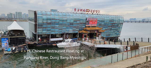
2-14) Pass the Dongbang Myeongju, Chinese restaurant
floating at Hangang River as see at the Photo 17.
2-15) Pass the Shincheon Nadeulmok Junction at
right as see at the Photo 18.
2-16) Pass the Jamshil Ferry Dock at left floating
at Hangang River as see at Photo 19. .
2-17) Pass the Jamshil Saenae Nadeulmok
Junction and Clock Tower, well-known as good meeting point as see at the Photo
20.
2-18) Pass Jamshil Daekyo Bridge and its Eodo,
fish-way and by pass Jamshil Daekyo Dike as see at the Photo 21.
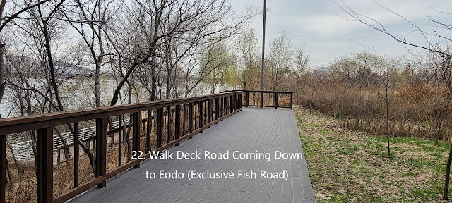
2-19) Walk the deck road down to the Jamshil Eodo,
fish-way path as see at the Photo 22.
2-20) Pass the Lotte World Tower at right, 555m
high and 125 story building and highest in Korea so far, No. 5 worldwide as see
at the Photo 23.
2-21) Pass the Jamshil Eodo, exclusive for fish-way
and by-pass Jamshil Daekyo Dike as see at the Photo 24.
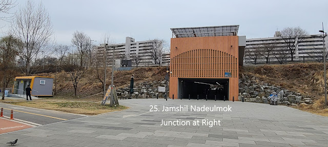
2-22) Pass the Jamshil Nadeulmok Tunnel
Junction at right as see at the Photo 25.
2-23) Walk the nice and neat Exclusive Walking
Road as see at the Photo 26.
2-24) Pass the Seongnaecheon Creek Bridge which
is under Jamshil Railway Bridge as see at the Photo 27.
2-25) Take Songpa Dulraegil Trekking Course as
see at the Photo 28.
2-26) Follow Arrow Mark at Songpa Dulraegil
Sign as see at the Photo 29.
2-27) Continue to walk Hangang Walking Road
guided with nice poplar trees at left as see at the Photo 31.
2-28) Pass the Olympic Daekyo Bridge and keep
walking toward Cheonho Daekyo Bridge as see at the Phot 32.
2-29) Pass the Poongnap Toseong Nadeulmok Tunnel
Junction as see at the Photo 33.
2-30) Pass the beautiful weeping willow trees
on way to Cheonho Daekyo Bridge as see at the Photo 34.
2-31) Turn
right at Cheonho Daekyo Bridge Junction as see the Photo 35 and 36.
2-32) Step
up to Cheonho Daekyo Bridge through connecting stairs from ground to the bridge
as see at the Phot 37 and 38.
2-33)
Turn left at stair junction to the bridge and move forward Cheonho Station in
Seoul Metro Line 5 or 8 as see at the Photo 39, 40 and 42.
2-34)
Nice View of 88 Olympic Expressway from Cheonho Daekyo Bridge as see at the
Photo 41.
2-35)
Enter into Gate 1 at Cheonho Station in Seoul Metro Line 5 or 8 as see at the
Photo 43 and 44.
3. Historic and Background Information
There are several places or spot where some
cultural and historic background which you may feel interest in or useful for
your better understanding. Please refer followings for brief explanation.
3-1) Yeongdong
Daekyo Bridge and Yeongdong Meaning
This bridge was built with 6 lane and 1,065m
long connecting Seongsu Dong in north Hangang River to Cheogdam Dong in south
Hangang River and officially opened in 1973 as 7th opening Hangang
River Bridge which was a role of Gangnam District Development. Yeongdong means
long bridge in East of Hangang River.
3-2) Cheongdam Daekyo Bridge and Cheongdam Meaning
This bridge was in 1993 built with 6 lanes
width and 1,211 m long which was designed double deck bridge, main deck for car
transportation and under deck for Seoul Metro Subway Line 7 and opened main
deck bridge in 1999 and under deck bridge in 2001 respectively. Cheongdam means
Clean Conversation, socially and politically unpolluted.
3-3) Jamshil Daekyo Bridge and Jamshil Meaning
This
bridge was built and firstly opened in 1970 with 6 lane width and 1,280m long
which was secondly opened in 1972 as 6th opening Hangang River
Bridges. Special design was reflected to dike and Eodo (fish-way) under the
bridge. This bridge was expanded to 8 lanes in 1997 and officially opened in
2003 and uniquely connecting to Seokcheon Lake and Lotte World Tower at south
Hangang River.
 |


댓글 없음:
댓글 쓰기