1. Date and Time : Nov 11, 2018 10:00~17:00
(7 hours including one hours break).
2. Location :
Sangnam-myeon (Town) and Girin-myeon (Town), Inje-gun (District), Gangwon-do
(Province)
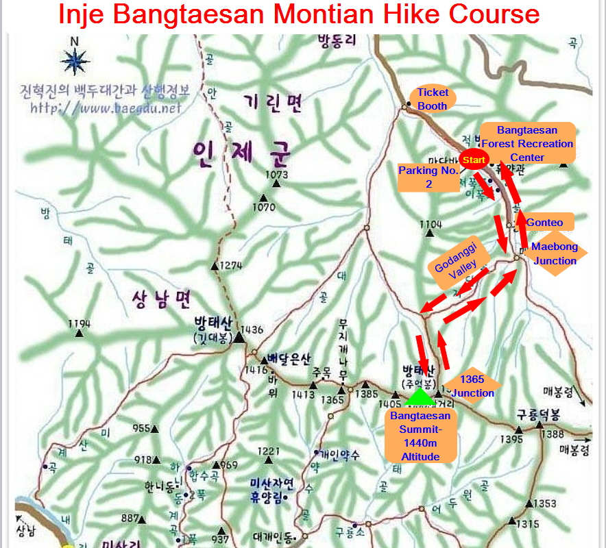
3. Distance and Course : About 13.63km.
Course is to start at Bangtaesan Forest Recreation Center Parking Lot No. 2 =>
Maebong Junction => Godanggi Valley => 1365 Junction => Bangtaesan
Jueokbong Summit (1,444m Altitude) => Back to the Parking Lot No. 2 through
the Same Ascending Course. Please refer to Inje Bangtaesan Mountain Hike Course
and
4.
Access
:
There
are various ways to the Dong Seoul Bus Terminal where you could use subway or
bus or taxis depend on your situation. You could take Inje Intercity Bus
Terminal at Dong Seoul Bus terminal and get off at the Terminal 2 hour and 10
minutes. But there is no proper public transportation from there to Bangtaesan
Forest Recreation Center which takes about 1 hour only by taxi for more than 40
km. Therefore it would be too long way to take a taxi for the trip. So you
would better take rent car instead.  |
1,444m Altitude Bangtaesan Jueokbong Summit Monument
|
5. Overall
Remarks.
Baegunsan (Mt.) holds Donggang (River). Donggang
(River) holding the "secret of ancient times" and "heavenly
sight" flows quietly from the deep mountains of Gangwon-do. Considering
this, the hike in Baegunsan (Mt.) gives you the feeling of becoming a fairy. To
hike in Baegunsan (Mt.), you should cross Donggang (River). You should also
cross the river back after the hike. But you can also ride in a boat to Seopsae
after coming down from Chiljongnyeong (Ridge) to Munhee village without
crossing the water. This is the way to enjoy both mountains and river at the
same time. But, the hike to Baegunsan (Mt.) usually starts from Jeomjae
village.
If you arrive at the saddle of the ridge after
crossing the river through the village and across the cliff diagonally on the
back, take the course to the ridge at the end of the cliff continuing
endlessly. The scenery of Donggang (River) viewed from this ridge is
magnificent. After the cliff road ends and the gentle ridge is passed, it is
the top. It takes 2 hours from Jeomje to the top. From the top to Jejang
village, a steep ridge composed of 5 peaks continues. Especially, this section
is quite dangerous since the trail hangs at the end of the cliff. You must be
cautious at all times and should not hike on rainy days or on wet grounds. In
the saddle right before the last peak, there is a passage leading down to
Munhee village. Since the road is gentle and wide, it seems like walking on
park roads. 30 minutes' walk from the crossroad will lead you to the riverside.
6. Detailed
Course Information
I was
traveling down to Bangtaesan Forest Recreation Center in Inje District,
Gangwondo Province early in the morning in Seoul at 07:00 hours on Nov 11, 2018
and arrived there about before 10 o’clock after less than 3 hours driving. When
I passed PNS Ticket Booth, they requested to pay parking fee as KRW3,000- per
car and heard there was Parking Lot No. 1 and 2 where Parking No. 2 was about
2km to Hike Starting Point, Parking Lot 1 was 2 km longer distance to Hike Starting
Position. I drive the car to the Parking Lot No. 2 for about 5 minutes and
parked the car there and checked hike course map. But there was no hike course
map and only walking course map available. I could easily find the way to walk
up to the hike since walking course was moving to Maebong Junction. I was just
walking on hike the course for a moment and found there was so clean and turbulent
rocky and stony stream at left which I should followed up with. I continued to
walk this road for about 10 minutes for the Parking Lot and met Maebong
Junction which I could take either way; 4.2km to the Summit at right or 2.7km
to the Maebong Peak at left. I took a right road and kept walking up on the
road for about 10 minutes more and reached next landmark stating as 3.6km to
the Summit at right and 400m to Bangtaesan Forest Experience Field. I have walked
there at the landmark without any hard or difficult so far but there was a foggy
on the road and carried on walking on the similar road for half an hour and
found somewhat steeper sloped wood stairs and oak tree forest. As I passed this
road for about 10 minutes, I faced 2nd wood stairs which was very heavily
sloped wood stairs for about half an hour and continuously walking on steeper
uphill road under support of rope guide rail for about 40 minutes more and
reached softer rocky and stony ridge road at oak tree forest. When I made hard
effort to climb on steeper uphill road for half an hour more, I was able to see
1365 Junction where junction mark stating as only 400m to the Summit at right
and 1.4km to Guryeongdeok. I turned right and found there was a Summit in front
which closely looked like touchable. I kept climbing on somewhat sloped road for
about a quarter minutes and finally
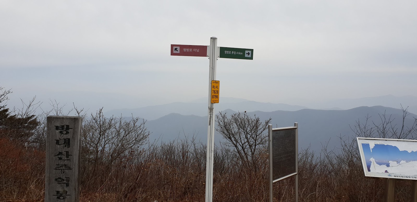
touched down the 1,444m Altitude Bangtaesan Jueokbong Summit looked around view
at the Summit and could not see clear scenery of surrounding mountains due to somewhat
heavy foggy around. I took a some photo around and descending the Summit
through the same road that I used this morning and eventually returned Parking
Lot No. 2 after about 3 hours descending from the Summit which means total 7 hours hiking.
 |
| Bangtaesan Recreation Center Parking Lot No. 2 |
 |
| Hike Starting at Parking Lot No. 2 |
 |
| Walking along with Turbulent Rocky and Stony Stream and Two Stepped Water Fall |
 |
| Maebok Ryeong Hill Junction; 4.2km to the Summit at Right or 2.7km to Maebong Ryeong Hill at Left |
 |
| Somewhat Sloped Wood First Stairs |
 |
| Oak Tree Forest Road After First Wood Stairs |
 |
| 2nd Longer and Highly Sloped Wood Stairs |
 |
| Steeper Sloped Tough Road |
 |
| Softer Stony or Rocky Ridge Road |
 |
| 1365 Junction; Only 400m to the Summit at Right or 1.4km to Guryeongdeok Peak at Left |
 |
| Bangtaesan Jueokbong Summit in Front after Right Turn at 1365 Junction |
|
| 1,444m Altitude Bangtaesan Jueokbong Summit Monument |
 |
| Around View of Surrounding Mountains at the Summit |
 |
| Descending Through the Same Road as I took this Morning |
 |
| Back to the Parking Lot No. 2 after 5 Hours Hike |
 |
| Typical Example Forest Log House, not so good and not so bad |


댓글 없음:
댓글 쓰기