레이블이 Yeongdong인 게시물을 표시합니다. 모든 게시물 표시

2022년 4월 3일 일요일

Updated : Hangang River Walking East Course 3 Alongside Hangang River, South from Shinbanpo Station to Apgujeonrodeo Sation in Seoul

 1.   Preface

Hangang River is one of Major River in Korea which is starting flowing down from the Taebeak City in Gangwon Province, North East to the Ganghwa Island in West Sea and which is almost dividing half of country from North to South. Total flowing distance is estimating as 494km. There are total number of bridges built around Seoul and it’s metropolitan in the Hangang River as 32 pieces. But I will arrange to walk Hangang River from Gangseogu district to  Hanam City in Kyeonggi Province which is estimated as total distance, 86 km and 26 walking hours and passing 22 bridges out of these total 32 bridges. Each course is arranging with about 12 km and 4 hours walking time and starting from near subway station and finishing at designated subway station. Please see more to Attached Walking Course Table and map below for bridges on the Hangang River.


2.   Course Guide Information

Hangang River Walking Course 3 is arranged from Sinbapo Station in Seoul Metro Line 9 to Apgujeongrodeo Station in Sinbudangseon Subway Line as about 13 km distance walking alongside Hangang River for about 4 hours, South including one hour break during the Course. We will pass four bridges at the Hangang River. Please see followings are summary map of the Course 3 and also liked to https://www.youtube.com/watch?v=qz7LYhqH2g8.


2-1) Exit Gate 2 and Start at Shinbanpo Station as see at Photo 1.

2-2) Walk toward Seoul Express Bus Terminal Junction as see at Photo 2.

2-3) Cross the Seoul Express Bus Terminal Junction as see at Photo 3.

2-4) Turn Left at the Junction and Move toward Banpo Bridge in Hangang River as see at Photo 4.

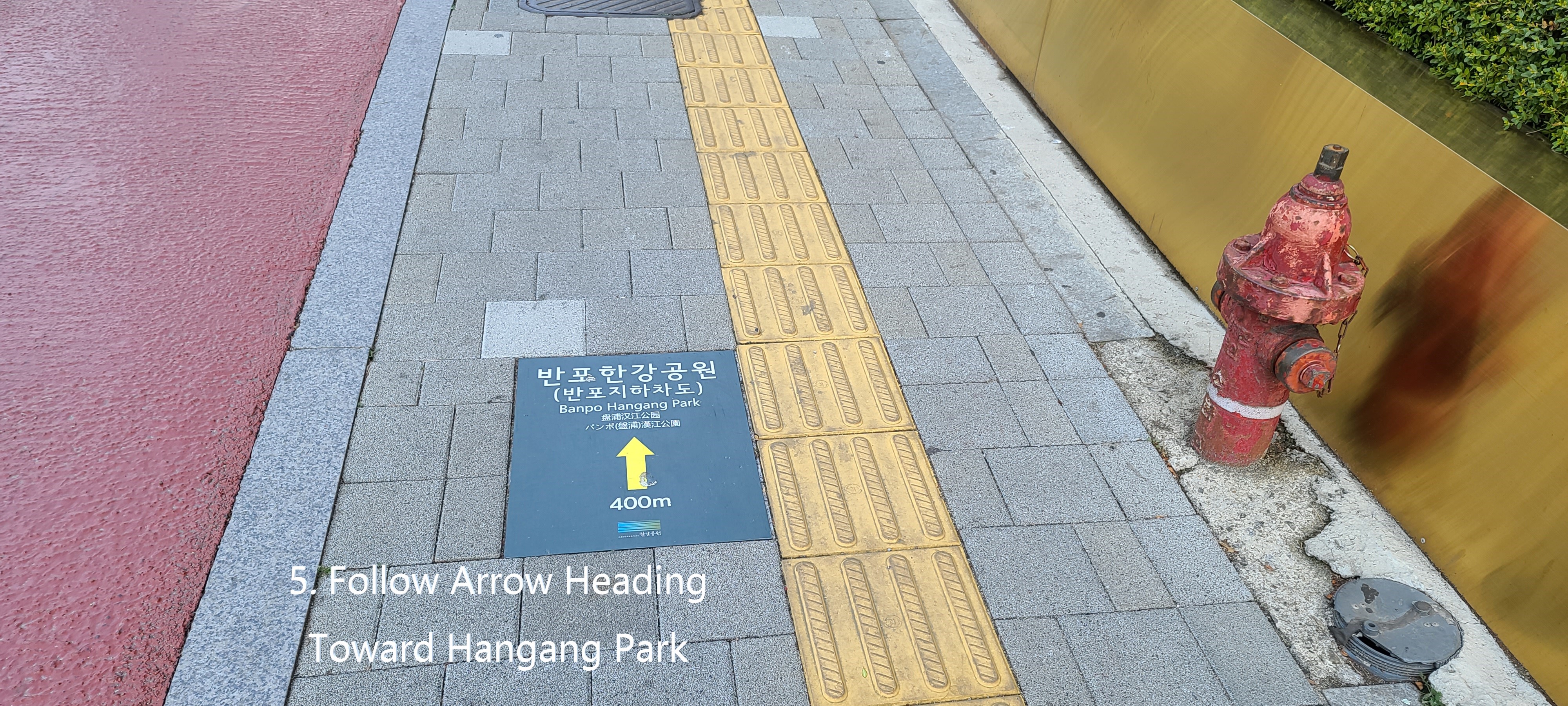
2-5) Follow Arrow mark as see at Photo 5.

2-6) Walk down through walk tunnel as see at the Photo 6.

2-7) Turn right at the under-tunnel junction as see at Photo 7.

2-8) Step down through under-pass tunnel stairs as see at Photo 8.

2-9) Turn right at rotary junction which is at end of the walk tunnel as see at the Photo 9.

2-10) Cross the rotary drive road and move toward Hangang River as see at Photo 10.

2-11) Turn right at the square which is under Banpo Daekyo Bridge and walk alongside the Hangang River as see at Photo 11.

2-12) Continue to walk toward Hannam Daekyo Bridge as see at the Photo 12.

2-13) Pass Jamwon Hangang Park and Break area as see at Photo 14.

2-14) Return the Hangang Walking Road from Hangang River Shore-Side Road as see at the Photo 15.

2-15) Separate from the Hangang Walking Road and walk exclusive walking road as see at the Photo 16.

2-16) Walk stone tiled road as feeling like as real country road as see at Photo 18. .

2-17) Pass the Seoul Wave Art Center for Gallery Café as see at the Photo 20.

2-18) Pass Monarch Yacht Club for pub and restaurant as see at the Photo 21.

2-19) Back to the Hangang Walking Road and move toward Hannam Daekyo Bridge as see at the Photo 22.

2-20) Pass the Hannam Daekyo Bridge toward Seongsu Daekyo Bridge as see at the Photo 26.

2-21) Pass the Break and Sport Facilities which is under Hannam Daekyo Bridge as see at the Photo 27.

2-22) Pass the Jamwon Nadeulmok Tunnel Junction as see at the Photo 29.

Shinsa Nadeulmok Junction at right as see at the Photo 16.

2-23) Pass ON for pub, café and restaurant as see at the Photo 30.

2-24) Pass the USCO for pub and restaurant as see at the Photo 31.

2-25) Keep moving toward the Dongho Daekyo Bridge as see at Photo 32.

2-26) Pass the Seongsu Daekyo Bridge as see at the Photo 34.

2-27) Drop by small park under Seongsu Daekyo Bridge as see at the Photo 35.

2-28) Join the Hangang Walking Road and keep walking toward Apgujeong Nadeulmok Tunnel Junction as see at the Phot 38.

2-29) Pass the Apgujeong Nadeilmok Tunnel Junction as see at the Photo 42.

2-30) Exit the Tunnel Junction and join the three way junction as see at the

either Photo 43.

2-31) Walk toward first four-way junction where Apgujeong Rodeo Subway Station is below as see the Photo 44.

2-32) Enter Gate 1 in Shinbundang Subway Line as see at the Phot 45.

3.   Historic and Background Information

There are several places or spot where some cultural and historic background which you may feel interest in or useful for your better understanding. Please refer followings for brief explanation.

3-1) Banpo and Banpo Daekyo 

Banpo was originated from Seori and Seori which means “brook flowing round and round looks like snake’s coiling which is inclusive of additional mean as looks like water over flow at the brook”. This Seori was changed its  pronunciation as Banpo taking into consideration writing in Chinese letter, no Chinese letter to Seori and Seori. Banpo Daekyo Bridge was built in 1982 to connect Seobinggo Dong, North of Hangang River and Banpo Dong, South of Hangang River. This bridge was firstly built two story structure in Korea and 1.2 km length. First story bridge is sometime sunken sometimes somewhat heavy rain but 2nd story bridge does not get any influence by normal heavy rain. This bridge was recorded at the Guinness Book on December 14, 2008 as the longest time water jetting bridge in the world.

3-2) Hannam  Daekyo Bridge

Hannam Daekyo Bridge was built at Hangangjin ferry dock which was a main transportation route from Hangang South to North. Traffic was inevitably heavy and heavy depend on time by time which is still one of heavy traffic jam bridge in Hangang River. This bridge was originally built with 4 lane and 913 m long in 1966 which was later expanded to 6 lanes in 1969.

3-3) Seongsu Daekyo Bridge  

This bridge was built and opened in 1979 with 8 lane and 1,161m long which was rebuilt in 1997 due to bridge collapse in 1994. This bridge was opened for mainly boosting the development of Yeong Dong area in south of Seoul where somewhat poorer development than Seoul core and downtown area  in north of Hangang River at that time. This bridge is now multihul function connecting between south and north in Seoul as well as between east and west in Seoul.

This bridge was collapsed in 1994 as bridge deck (about 50m) was falling down between bridge column 5 and 6. Please see following collapsed picture. Korean Government took a decision not to repair the collapsed bridge but to completely rebuild. The Collapsed reason was confirmed due to poor maintenance at the bridge column foundation which was affecting by  all-time flowing river.


3-4) Dongho Daekyo Bridge

This bridge was starting to build between Oksu Dong in north Hangang River and Apgujeong Dong in south Hangang River in 1980 as old name as Geumho Daekyo Bridge which was opened in 1984 as present name as Dongho Daekyo Bridge, changing its name in reference to old name of Dongho Ferry Dock at Oksudong area. This bridge was built with 8 lane width and 1,161m long. 


2018년 11월 7일 수요일

Choongbuk Yeongdong Minjugisan Mountain Hike in Korea- Minjugisan Forest Recreation Center Course


1.     Date and Time : Nov 1, 2018 07:00~12:30 (5 hours and 30 minutes including half an hour break).
2.     Location: . Buhang-Town, Gimcheon-City, Gyeongsangbuk-Province and Muju-District, Jeollabuk-Province and Yonghwa-Town, Sangchon-Town, Yeongdong-Districr, Chungcheonbuk-Province
3. Distance and Course : About 16.95km. Course is to start at Minjugisan Forest Recreation Center => Limdo Hyeushik (Rest and Break Pavilion) => Limdo Junction => Daepiso (Shelter) => Minjugisan Summit (1241m Altitude) => Back to the Minjugisan Forest Recreation Center. Please refer to the Choongbuk Yeongdong Minjugisan Hike Map and https://www.youtube.com/watch?v=DRUsosiT128
4.     Access :
There is several ways to connect “ITX Seoul Station” connecting by subway lines No. 1, 4 and AREX). Please walk to the ITX Seoul Station from the Subway Station taking 2 minutes for 240m and check boarding gate number at the information sign board and follows the information and get on ITX bound for Yeongdong taking 2 hours and 9 minutes. When you get off at the Yeongdong Train Station, please walk to Yeongdong Station Bus Stop taking 2 minute for 102m. You could get on local bus No. 143 and get off at Samchonri Bus Stop taking 1 hour and 37 minutes for 38 bus stop passing. You could walk to Minjugisan Recreation Center taking 10 minutes for 676m. Please refer more details to the “Transportation from ITX Seoul Station to Minjugisan Forest Recreation Center”. You could simply take reverse course on your way back home. I could estimate total transportation is about 4 hours and half an hour including waiting times for one way which comes total 9 hours for round trip. But you would reduce this transportation time to 7 hours for round trip in case you use private car or rent car which you could save two hours for the transportation. 
1,241m Altitude Minjugisan Summit Monument 

5.     Overall Remarks.
Minjujisan (Mt.) covers parts of 3 provinces; Yeongdong in Chungbuk, Gimcheon in Gyeongbuk, and Muju in Jeonbuk, and draws an 8-kilometer-long main ridgeline to the north, connecting Gakhosan (Mt.), Seokgibong (Peak), and Samdobong (Peak).
Sobaek mountain range stretching down to the southwest from Taebaek mountain range, the spine of Korea, goes down to Chupungnyeong (Ridge) and rises again to form Minjujisan (Mt.), located 15km from Chupungnyeong to the southwest. This place holds the Mulhangyegok (Valley) which is famous for its scenery. Anyone who has ever paid a visit here says that they have never seen such a beautiful place. Especially, the valleys connected from Daebul-ri to Seokgibong (Peak) and those from Mulhan-ri to Samdobong (Peak) are over 5km in length, and renowned as the places that have not been damaged at all. Also, the ridge between Samdobong and Seokgibong shows a splendid scenery with full of various shrubs, azaleas and royal azaleas. Also, this place holds beautiful sceneries such as Okso, Eumjuam, Euiyonggolpokpo (Waterfall). On Samdobong (Peak), there exists a monument of peace which people from 3 provinces (Chungbuk, Gyeongbuk, Jeonbuk) have  raised to live peacefully without dispute
6.     Detailed Course Information   
     I was staying at Minjugisan Creation Center Lodge for three night covering near mountains listed at 100th Korea Mountain like Cheontaesan, Daedunsan and Minjugisan and could star to climb the Minjugisan quite early in the morning, 07:00 hour. This Lodge is a condominium style where we have to prepare everything for temporally living like toiletries including necessary towels and food stuff, no shop at the Center paying KRW35,000- per day. There is not bed at the Center Lodge and sleeping on floor with matrass and blanket which is available at each room. I used to try to arrange this kind of forest lodge taking into account nearest and convenient to planned or targeted mountains here and there. Anyway I came to hike start junction at the Center as see at the photo and started to walk on mountain transportation road which is wide and easy walking. This mountain transportation road was originally arranged for transportation of forest products or related stuff. But we could walk on this road comfortably for about 20 minutes and found landmark stating as 4.5km to Minjugisan Mountain Summit. As I walked a few steps, I saw one neat pavilion at right which we could take break and rest. I was continuously walking through this road and found deep foggy around here and there on the course which made me somewhat mysterious feeling under no artificial interference like human sound or human made equipment noise. I kept walking on the road for about a quarter minutes and saw next landmark stating as 4km to the Summit. I carried on walking softly for half an hour and reached next junction mark stating as 2.8km to the Summit at straight. When I was walking on the same road, I found sun was rising and lighting to colorful mountain and valley which looked as great nature view as see at the photo. I was keeping walking on the road for about half an hour and met junction where either way going to the Summit at straight or 5.5km to Ahnjeonggol at left. I took straight and walking on different condition road than mountain transportation road before which was highly sloped and narrow hiking road and somewhat slippery rocky road. I started to feel hard to breath time by time according to higher elevation. As I was struggled against this so steeper road for about a hour, I met one small spring which was a origin of Yongwahcheon- Stream which looked as so insignificant water follow down. I was wonder how this tinny water getting bigger and bigger and finally changing to big river, Yongwha River. I was really and hardly fighting against so deeply steep uphill road for an half an hour more and reached junction mark; only 300m to the Summit at right and 2.9km to Gakhosan Mountain at left. I turned right and walking on very sharp and narrow road for about 10 minutes and finally touched down Minjugisan Summit Monument stating as 1,241m altitude and looked around surrounding elegant mountains holding foggy could which looked as magnificent or spectacular landscape or nature scenery. I took down on the camera as see at the photo. It was minus 2 degree C in the morning at foot of the mountain this morning which provably minus 4 degree C at the Summit area. I saw frosted trees just below the Summit which made separate scenery between frosted area and unfrosted area. I found this separate landscape was extraordinary picture which I could take only at that time since frost so quickly melted soon. I decided to descend the Summit through same road which I took this morning and back to the Minjugisan Forest Recreation Center after two and half an hour downhill walking from the Summit.    

Hike Course Start at the Yeongdong Minjugisan Recreation Center 

Waking on Mountain Transportation Road

Rest and Break Pavilion at Walking Course

4.0 km to the Summit Junction Mark

Continuously Waking on Easy Walking Road

2.8km to the Summit Junction Mark

Keep Walking on the Same Road

Elegant Landscape at Mountain and Valley

Junction Mark; 1.4km to Summit at Straight or 5.5km to Ahnjeonggol at Left


So Highly Sloped Gravel or Rocky Road

Original Spring of Yongwha River

Junction Mark; Only 300m to Summit or 2.9km to Gakhosan Mountain

1,241m Altitude Minjugisan Summit Monument 


Spectacular Sounding Mountains with Foggy Cloud

Spectacular Sounding Mountains with Foggy Cloud

Spectacular Sounding Mountains with Foggy Cloud

Frosted Trees and Non Frosted Trees View 

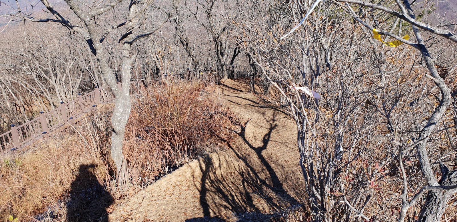
Descending through Same Ridge Road at Summit


Back to Parking Place in Minjugisan Recreation Center