1. Date and Time : May 9, 2018 10:30~16:30 (6 hours
including break one hours).
2. Location : Paju at Gyeonggi Province in Korea.
2. Location : Paju at Gyeonggi Province in Korea.
3. Distance and Course : About 12.36km. Course is to start Parking Lot at Baekwun Valley =>Heungryongsa Temple=> Baekwunsan Summit (903.1m Altitude) => back to Parking Lot at Baekwun Valley.
4. Access :
5. Overall Remarks.
https://www.youtube.com/watch?v=YTc-AkskZrY&feature=youtu.be
6. Detailed Course Information
When
I parked the car at parking lot, I was a bit surprised to see no car parking at
the parking lot, only one car. I checked Course Information first of all before
start to climb and found Course 1 should be suitable for my today in view of
returning time from this parking lot by latest 16:00 hours and started to move
up and found Heungryongsa Temple, situated at left and visited the temple with
careful appreciation and learned this temple has been built by Doseonguksa
(National Buddhist Monk) at late Shilla Dynasty who made a three wooden birds
and threw the birds to air and found all three birds perched on Baekwunsan. Therefore
he finally made a choice to build the Heungryongsa Temple at present location.
It seems this temple looks like shinny and dignity style which expose invisible
spiritual force to the people. I crossed two small bridges which are standing
across the Baekwun Valley Stream as soon as I walk out the temple where there
is a landmark arrowing to Corse 1 and Course 5 respectively in reference to the
Course Information. As I approached to starting point to climb the mountain, I felt
on spot I became moving into natural therapy for mental and physical. I walked
up along with Baewun Valley Stream and moved up on steep stairs on sharp sloped
hill for about 20 minutes from the start and
reached landmark as 3.42km to the Summit. I changed to climb through Baekwun
Ridge from there which was a bit milder slope than before and kept climbing
following guide rope and sometime detoured right or left due to big rock obstacle
at ridge. When I walked on these paths for about 40 minutes, I met landmark
showing 2.71km to the Summit. I walked up on ridge for another 40 minutes and
met next landmark saying 1.87km to the Summit. Somewhat slippery rock path was
waiting for me after passing the landmark which we should pay attention to
climb with slippery as well as higher steep. It was right time for lunch. I was
looking for proper place for lunch and found a good point and enjoyed for about
one hour. I kept moving up for about half an hour and found landmark 1.2km to
the Summit. When I walked up for about 15 minutes from previous landmark, I
found very beautiful royal azalea starting to blossom which is light pink standing
on the way up and took the flower to photo. I reached next landmark saying 600m
to the Summit after passing the Royale Azalea. I have seen there were so many
royal azalea standing beside the climb path on the Baekwun ridge, left and
right which shows refreshed energy to climbers with so nice and beautiful
flowers and looks like neat and dandy. I kept walking up on same path sometime
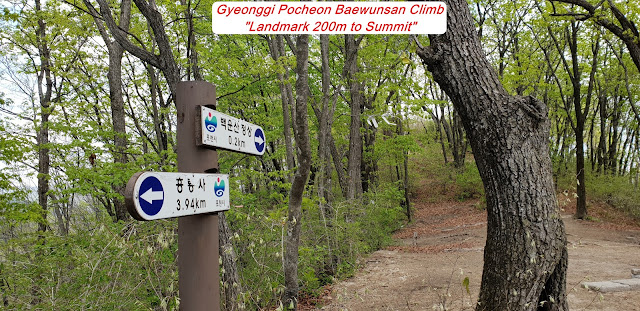
somewhat steep rocky or hilly for about 20 minutes and reached landmark saying
200m to the Summit. I felt I was very near to the Summit when I saw the
landmark and rushed up to the Summit for about 10 minutes and touched down to
Baekwunsan Summit, 903.1m altitude and kept the picture of this Summit to the
Photo nicely and looking around the Summit. But I could unfortunately not see
anything around because of so thicker forest and taller three around the Summit.
I therefore started to downhill through the same path I came up so far with more
careful for slippery for granite somewhat bigger sand spreading on hill and
ridge. When downhill for about one hour, I found some open space which I could
see some neighboring mountain peak around the Baekwunsan and took some photo. I
kept walking down about one more hour; I reached the starting landmark standing
in front of 2nd bridge where I saw so good and fantastic view of
Baekwun Valley Stream roaring a sound of downstream. I rhttps://drive.google.com/drive/folders/0B1ThCOBdyTddQ0syODZORDlybXMeturned the parking lot
after 10 minutes from there.


댓글 없음:
댓글 쓰기