1. Date
and Time : May 24, 2018 09:30~17:00 (7 hours and 30 minutes including
break one hours).
2. Location
: Wonju at Gangwondo Province in Korea.
3. Distance and Course : About 13.42km.
Course is to start KNPS Hwanggol Information => Iepseoksa Temple => Hwanggol
Samgeori => Birobong Samgeori => Birobong Summit (1288m Altitude) => Birobong
Samgeori => Hwanggol Samgeori => Iepseoksa Temple => KNPS Hwanggol Information.
4.
Access
:
There are various ways to reach the Seoul Express Bus Terminal where you will take express bus bound for Wonju Express Bus Terminal, non-stop and taking one and half an hours. As soon as you arrive, you should walk to Wonju Intercity Bus Terminal, 118m where you should get on bus No 2-1. You will get off at Musan Cheolkyo Bus Stop after about 15 minutes and 9 bus stops. You should ask bus driver saying simple Musan Cheolkyo? He would say to you “Yes” and provably notice to you when he arrives at Musan Cheolkyo Bus Stop. As you get off, you should walk to KT Branch Bus Stop, about 71m and 1 minute where you should get on Bus No 82 which you get off at Myungsung Remicon Bus Stop, 31 minutes and 18 times bus stops. You would better ask the driver as Myungsung Remicon? He provably answers to you “Yes” and notice to as soon as arrive at Myungsung Remicon Bus Stop. When you get off, you should walk to KNPS Hwanggol Information which takes about 27 minutes for 1.8km. On your way back, you simple take reverse curse as above. Please refer to the map of “Transportation from Seoul Express Bus Terminal to KNPS Hwanggol Information”. I estimate total transportation time from Seoul Express Bus Terminal to t KNPS Hwanggol Information 3 hour and 30 minutes for one way which estimate about 6 hours for round trip. But you would reduce this transportation time to 4 hours for round trip in case you use private car or rent car which you could save two hours for the transportation.
4.
Overall
Remarks.
There are five major climb courses which are Guryongsa Temple Course, KNPS Hwanggol Information Course, Gwaneumsa Temple Corse, Bomunsa Temple Course and KNPS Bugok Information as introduced at the “Chiaksan Climb Curse”. I chose the KNPS Hwanggol Information which would be shortest way to climb the Chiaksan Summit (Birobong). It was the hardest course from Iepseoksa Temple to junction at ridge, 600m which is really so hard and difficult to climb since so steep hill as well as stone and rocky road, not so easy keeping balance to walk. It seems I might spend my energy about 30% at this short distance. You would figure how hard and difficult through attached phot0.
There is interesting story at Juineommi Hill Observation which you should see after passing Iepseoksa Temple and above so hard ridge junction and Hwanggol Samgeori. There was small temple at the Observation area where one ordinary month lived old days. But there were so many rats lived together at the temple which he could not live any more due to rat’s disturbance. He decided to give off the temple and left. Thereafter the rats faced difficult to survive due to insufficient food and they also left the temple and climbed over the Juineommi Hill.
Iepseoksa
Temple is rather well known for Cheonseoktap Pagoda which King “Taejong”
instructed to erect for Won Cheonseok. The Taejong was eager to see him and
visited here but failed and decided instead to erect the Cheonseoktap Pagoda
for his memory. Iepseoksa temple is remotely located at higher valley with transparently
clean water stream, elevation about 740 m altitude.
5.
Detailed
Course Information
As
seen at the photo attached, you could easily walk on paved road with asphalt at
beginning up to Iepseoksa Temple for about 40 minutes from the KNPS Hwanggol
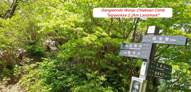
Information. You would meet landmark saying as 3.7km to Birobong Summit on the
way up to Iepseoksa Temple. But as soon as you pass the temple, you should bear
in mind you must tackle over so steep and slippery rocky road from the temple
to ridge junction for about 45 minutes. You would of course sometimes walk on wooden
stairs but mostly climb such hard road or path and reached landmark saying as
1.9km to Birobong. I think remaining course would be better than before and no
more such a so exhausting course. When I climbed on somewhat steep ridge for
about 45 minutes, sometime on log stairs, I met landmark as 1.3km to Birobong.
I walked up for about 15 minutes and reached Juineommi Hill Observation which
story is explained at above article 4. It was somewhat dust level was high
which I could not take nice photo around scenery at the Observation. But I found
so beautiful Royal Azalea on the way up which blossom late and took a phot as
closely as I could do. When I climbed sometime on square bar stairs for about
15 minutes more, I saw so nice view of Birobong somewhat remotely position and
took a nice view at photo. I kept walking up the wooden and rubber stairs for
about half an hour, I finally touch down Birobong. 1288m altitude after 3 and
half an hour so hard endeavor. It is principally comparably easy from the
Birobong to Iepseoksa Temple because all road are downhill in general. I walked
down sometimes on wooden stairs, log stairs. oak tree forest and so on for
about one 1 hour and 20 minutes and reached ridge junction saying 600m to
Iepseoksa Temple, so hard and steep and slippery hill. I was very carefully moved
down to Iepseoksa Temple after 25 minutes downhill. As I walked on easy and comfortable
paved road after Iepseoksa Temple for about 30 minutes, I successfully returned
KNPS Hwanggol Information.


