레이블이 Bukhansan인 게시물을 표시합니다. 모든 게시물 표시

2019년 1월 10일 목요일

Updating Different Munsubong Course Hike to 2018-04-22 Seoul Bukhansan Mountain Nahanbong Hike – Samcheonsa Temple Course


1.   1. Date and Time : Jan 09, 2018 09:30 ~16:00 (6 hours 30 Minutes including one hour break).
2.   Location : Eunpyeong-gu (District), Seoul City, Korea.

3.  2. Distance and Course : About 8.9km. Course is to start at Samcheonsa Temple Parking Lot => Buamdong Amun (small gate) => Nawolbong Peak (571m Altitude) => Nahanbong  Peak (581m Altitude) => 715 Bong Peak (715m Altitude) => Munsubong Peak (727m Altitude) => Cheongsudong Amun (small gate) and back to Samcheonsa Temple Parking Lot. Please refer to Bukhansan Munsubong Peak Hike Course Map and https://www.youtube.com/watch?v=kcwMgbn43k4&feature=youtu.be 

4.     3. Overall Mountain Explanation.
Inside the Samgaksan mountain, alternative name of Bukhansan and triangle mountain among Baekwundae Summit (836.5M Altitude), Mankyungdae Peak (799.5m Altitude) and Insubong Peak ( 830.6m Altitude) as nominated as a National Park, there are lots of clean and spectacular valleys among major rock peaks made of granite. It gives a beautiful view, and there live over 10,300 species of animals and plants inside. Also, it offers various historical and cultural relics including Bukhansansung (Fortress) which has the history of 2,000 years since the era of 3 States and over 100 temples and shrines. It is known to climbers that hiking course from Uisangbong Peak to Munsubong Peak through Yongcheulbong Peak, Yeonghyeolbong Peak, Jeungchuibong Peak, Nawolbong Peak, Nahanbong Peak, 715 Bong Peak are the most hard and severe hike course at Bukhansan Mountain.


5.   4. Detailed Hike Course Explanation.
I parked a personal car at Samcheonsa temple today since I started to ascend to Buamdong Amun (small gate at fort castle) from Samcheonsa temple and turning right at the Amun Junction to continuously climb over four peaks, Nawolbong Peak, Nahanbong Peak, 715 Bong Peak (715m Altitude) and Munsubong Peak (727m Altitude) and down hilled to Cheongsudong Amun Junction sand back to Samcheonsa Temple Parking Lot. I checked and confirmed at Weather Forecast dust level was fine and good before move to the Samcheonsa Temple and found dust level was not so good and clear when I arrived at the Temple as see at the photo. I prepare to climb the Munsubong Peak hike course fine and briefly looked around temple and Mayae Yeorae Ipsang Standing Buddha engraving at big rock. But I could not approach the temple main hall due to renovation or repair works. I started to ascend the Bukhansan through valley stream and heading to Buamdong Amun for a quarter minutes and found first landmark stating as 2.4km to Bibong Peak and 2.8km to Daenammun at straight. I carried on the same rocky and stony road for some more half an hour and reached junction mark; 2.3km to Daenammun at right and 900m to Buamdong Amun at left. I turned left at the junction and headed to the Buwangdong Amun Junction and arrived at the Junction after about 40 minutes hard uphill road. I was expecting dust situation would be somewhat improved but it was similar situation, no improvement. I turned right at the junction and kept on walking slopped ridge road for 20 minutes and found so spectacular view of Bukhansan Summit as see at the photo which is at middle of the picture and Mankyungdae Peak at right and remotely Insubong situating between these two peaks. I also saw peculiar rocks at Nawolbong Peaks and Yeonghyeolbong Peak and Jeungchuibong peak slightly down below as see at the photo. I was continuously heading to Nahanbong Peak about half an hour more and reached Nahanbong Peak where I could somewhat closely see 715 bong and Munsubong which was sometimes hard course climbing over so steep and slippery rock under full support of safety steel rope and anchor. I struggled on these hard and difficult roads for about 40 minutes and touched down Munsubong Peak (727m Altitude) and shot nice picture of around spectacular peaks and weird rocks. I down hilled as soon as I finished shots at Munsubong Peak and got down to Cheongsudong Amun Junction after about a quarter minutes and confirmed branching road to 4.2km to the Samcheon Information Center at left. I turned left at the junction and walking down through steep downhill road for about 15 minutes and met junction between 1.5km to Bibong at straight and 3.5km to Samcheon Information Center at right and turned left and continuously descending on steep rocky road for about 40 minutes and reached landmark stating as 2.4km to Samcheon Information Center at straight. I found and felt road conditions were worse and tougher than before and even sometime hard to find correct road because bigger rock and fallen leaves covering the road. I was walking down through these raod more carefully and sometime checked and checked again. When I almost struggled on these tough and hard road for some more half an hour and returned to three way Junction, 1.9km to Samcheon Information Center at left and 900m to Buamdong Amun at right, where I passed this junction this morning on my way heading to the Buamdong Amun. I turned left at the junction and carried on the same rocky sloped road at or along with the stream for half an more and returned Samcheonsa Temple Parking Lot after six and half an hour hiking including one hour break.

Samcheonsa Temple Parking Lot

Samcheonsa Maae Yeorae Ipsang Standing Buddha Engraving on Big Rock

Maae Yoerae Ipsang Standing Buddha

First Landmark; 2.4km to Bibong Peak and 2.8km to Daenammun at straight

Landmark; 2.3km to Daenammun at right and 900m to Buamdong Amun at left

Buwangdong Amun

Buwangdong Amun Junction; ; 1.5km to Daenammun at right and 2.8km to Samcheon Information Center


Peculiar rocks at Nawolbong Peaks 


Yeonghyeolbong Peak and Jeungchuibong peak slightly down at Nawolbong Peak


Series of Jeungchuibong Peak, Yonghyeolbong Peak and Yongchulbong Peak at Nawolbong Peak

Munsubong Peak (727m Altitude) at Nahanbong Peak


Odd Rocks Around Munsubong Peak

Spectacular View of Bukhansan Summit at middle of the Picture, Mankyungdae Peak at right and remotely Insubong situating between these two peaks

715 Bong Peak (715m Altitude); 400m to Daenammun (Great South Gate)


Nawolbong peak and Nahanbong Peak Viewing at Munsubong Peak


Spectacular Peaks and Weird Rocks


727m Altitude Munsubong Peak

Choengsudong Amun Junction; 4.2km to Samcheon Information Center at Left 

Junction Mark; 3.5km to Samcheon Information Center


Junction Mark;  1.9km to Samcheon Information Center at left and 900m to Buamdong Amun at right

Returned Samcheonsa Temple Parking Lot after six and half an hour hiking including one hour Break


2018년 9월 28일 금요일

Updated Hike - Seoul Bukhansan Mountain Hike in Korea-Baewundae Summit Course.


1.    1. Date and Time : Sept 27, 2018 11:0~17:00 (6 hours including break one hours).
2.    Location : Bukhansan Mountain in Seoul.
3. Distance and Course : About 10.69km. Course is to start NPS Bukhansansung Information =>Daeseomun => Muryangsa Temple => Daedongsa Temple => Ammun Gate => Baekwundae Summit (856.5m Altitude) =>Back to NPS Bukhansansung Information through the ascending course. Please refer to “Bukhansan Baekwundae Hike “Course Information” attached herein and to the link at https://www.youtube.com/watch?v=pvu1LsaJMCg


3.    4. Access
There is various ways to come to Bukhansansung Information by means of public transportation. But I suggest you may use Subway (Line No. 3 or 6) Line connecting to local Bus line (No. 34) which you get off at subway-Bulkhwang Station and exit Gate 8 and walk about walk total 200m at exit direction as explained at Change Map attached. Please take Green Color Bus No. 34 at Bus Stop (ID:12-021) and move (16 stops and about 26 minutes) and get off at Bus Stop (ID:12-233)-Bukhansansung Entrance. You may carefully check each Bus Stop ID at 2 or 3 stops before arrival as explained at Get off Map. Please note each Bus Stop has always independent ID number as shown at photo-Bukhansansung Entrance Bus Stop. You may simply return to your original position through reverse clurse as stated above.
I could estimate total transportation as 3.0 hour for one way from Subway Yongsan Station to Bukhansansung Entrance Bus Stop which comes 6 hours for round transportation. But you would reduce this transportation time to 4 hours for round trip in case you use private car or rent car which you could save two hour for the transportation. 

4.  5. Outline and Summary
      Inside the Samgaksan (Bukhansan) (Mt.) national park, there are lots of clean valleys among major rock peaks made of granite. It gives a beautiful view, and there live over 10,300 species of animals and plants inside. Also, it offers various historical and cultural relics including Bukhansanseong (Fortress) which has the history of 2,000 years since the era of 3 States and over 100 temples and shrines. It provides various views and places to learn ecology, culture and history. Samgaksan (Bukhansan) (Mt.) has various flowers blooming one after another in spring time, making it a land of fairy tales. There cannot be any other paradise when you are resting upon a valley with thick forests and clean waters in summer. In autumn, when you are following the road next to Bukhansanseong, Historic Relics No. 162, you can feel the solitude of the autumn itself. And in winter, the snow covered Insubong (Peak), Baegundae, and Mangkyeongdae will give you the mystic taste of purity and divine nature.

5. 6. Detailed Course Information
As shown at the photo of the Bus Stop-BWD Entrance, you will meet the three way junction at the same direction as the Bus is running and move about 10m forward from Get Off Bus Stop and turn right at the Junction and walk to Bukhansan (BHS) direction about 510 m and 10 minutes from the junction where you could meet three way junction again just in front of  BHS Information Booth at left. You could easily and comfortably walk on Paved with concrete block 
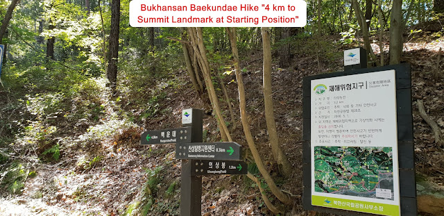
about 10 minutes and meet Landmark branching to Baekwundae Summit and Uisanbong Peak. But I took a straight direction where it said as 4km to the Summit and meet Yongamsa temple after another 10 minutes walking. You keep walking on the same road about 15 minutes and meet Daeseomun, Main West Gate at Bukhan Sanseong Fort Castle as you see at the Photo. It was early spring last year when I came over this road which was cherry blossom road. But It was very green trees and grasses which were preparing for season change to winter soon. I could feel very fresh and clean air on the way and somewhat emotionally excited under so nice weather. As I walked through such an excellent road for about 10 minutes more, I reached the Muryangsa temple which looks more elegant than in spring due to well matching or harmony to autumn. When I finished quick around the temple, I saw fantastic view of Wonhyeobong Peak, Yeomchobong and Jangkunbong on the road at left and took a photo and video. I kept walking up on the road for about 5 ~6 minutes and met the Junction between 2.6km to the Summit at left and 4.1km to the Summit at right. I choose left course and moved for 2 ~3 minutes and reached changing road becoming narrow and steep path mostly with stone stairs and ascended this raod for about half an hour and touched three way junction again as left direction leading to 400m to Bukmun (Great North Gate) and as straight direction leading to 1.6km to Baewundae Summit. I moved up straight and continued to cross wooden bridge at valley and climb rocky steep hill for 20 minutes and reached landmark stating as 1.3km to the Summit. I came across somewhat steep rocky narrow path with steel rope support and kept walking the similar way for about a quarter minutes and touched break and rest place and somewhere around middle between junction to junction and took a short break. I continued to ascend similar road and wooden stairs for half an hour and reached junction staying as 400m to the Summit or to the other Peak. I took a Summit Course and ascended on the wooden stairs for about 5 minutes and reached Ammun Gate Junction where I could take left course climbing up to the Summit or where I could go straight down to Uiedong Course which I took last time. When I climbed over the big rocky road and saw so beautiful Mankyungdae Peak as you see at the photo and looked up to straight and found so nice view of Baekwundae Summit with many people walking up and down through narrow sloped path. There was small peak at the middle and top which I could see remotely at the photo. I turned left again and found so nice and fantastic peaks surrounding the Summit and left the picture at the photo along with some others. When I climbed on this rocky road, I was jammed time by time depend on up-jam or down-jam and ascended for about 10 minutes and found so close and impressive view of Insubong Peak at right and kept moving up to the Summit and touched down the Summit ( 836m Altitude) after about 10 minutes endeavor. I decided to descend the mountain due to crowded at small summit area as soon as the Summit. I willingly took a photo to Dobongsan Mountain on the way down which is located at North East from Bukhansan Mountain as you see at the photo. I returned NPS Bukhansan Booth via Ammun Gate Junction after 3 hours from the Summit.