2022년 4월 3일 일요일

Updated : Hangang River Walking East Course 3 Alongside Hangang River, South from Shinbanpo Station to Apgujeonrodeo Sation in Seoul

 1.   Preface

Hangang River is one of Major River in Korea which is starting flowing down from the Taebeak City in Gangwon Province, North East to the Ganghwa Island in West Sea and which is almost dividing half of country from North to South. Total flowing distance is estimating as 494km. There are total number of bridges built around Seoul and it’s metropolitan in the Hangang River as 32 pieces. But I will arrange to walk Hangang River from Gangseogu district to  Hanam City in Kyeonggi Province which is estimated as total distance, 86 km and 26 walking hours and passing 22 bridges out of these total 32 bridges. Each course is arranging with about 12 km and 4 hours walking time and starting from near subway station and finishing at designated subway station. Please see more to Attached Walking Course Table and map below for bridges on the Hangang River.


2.   Course Guide Information

Hangang River Walking Course 3 is arranged from Sinbapo Station in Seoul Metro Line 9 to Apgujeongrodeo Station in Sinbudangseon Subway Line as about 13 km distance walking alongside Hangang River for about 4 hours, South including one hour break during the Course. We will pass four bridges at the Hangang River. Please see followings are summary map of the Course 3 and also liked to https://www.youtube.com/watch?v=qz7LYhqH2g8.


2-1) Exit Gate 2 and Start at Shinbanpo Station as see at Photo 1.

2-2) Walk toward Seoul Express Bus Terminal Junction as see at Photo 2.

2-3) Cross the Seoul Express Bus Terminal Junction as see at Photo 3.

2-4) Turn Left at the Junction and Move toward Banpo Bridge in Hangang River as see at Photo 4.

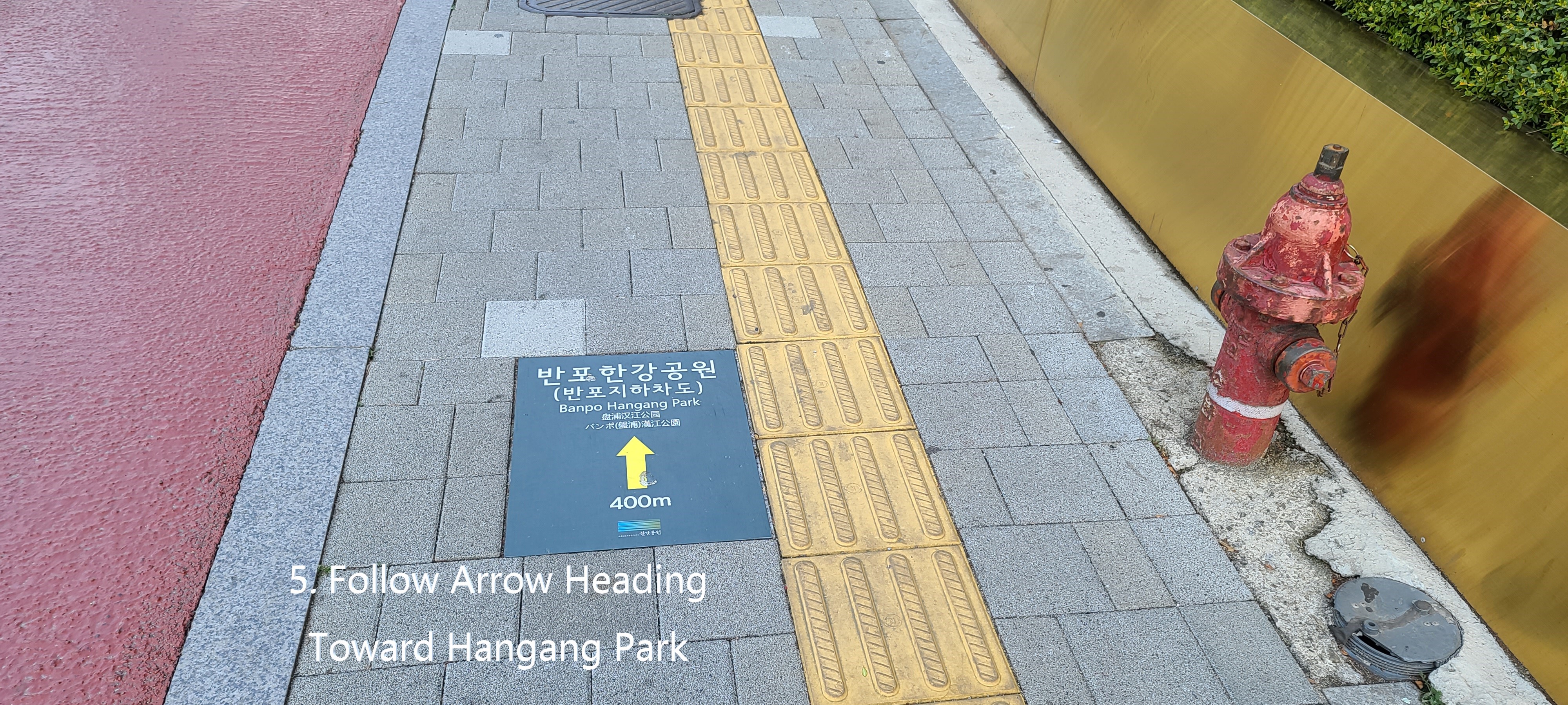
2-5) Follow Arrow mark as see at Photo 5.

2-6) Walk down through walk tunnel as see at the Photo 6.

2-7) Turn right at the under-tunnel junction as see at Photo 7.

2-8) Step down through under-pass tunnel stairs as see at Photo 8.

2-9) Turn right at rotary junction which is at end of the walk tunnel as see at the Photo 9.

2-10) Cross the rotary drive road and move toward Hangang River as see at Photo 10.

2-11) Turn right at the square which is under Banpo Daekyo Bridge and walk alongside the Hangang River as see at Photo 11.

2-12) Continue to walk toward Hannam Daekyo Bridge as see at the Photo 12.

2-13) Pass Jamwon Hangang Park and Break area as see at Photo 14.

2-14) Return the Hangang Walking Road from Hangang River Shore-Side Road as see at the Photo 15.

2-15) Separate from the Hangang Walking Road and walk exclusive walking road as see at the Photo 16.

2-16) Walk stone tiled road as feeling like as real country road as see at Photo 18. .

2-17) Pass the Seoul Wave Art Center for Gallery Café as see at the Photo 20.

2-18) Pass Monarch Yacht Club for pub and restaurant as see at the Photo 21.

2-19) Back to the Hangang Walking Road and move toward Hannam Daekyo Bridge as see at the Photo 22.

2-20) Pass the Hannam Daekyo Bridge toward Seongsu Daekyo Bridge as see at the Photo 26.

2-21) Pass the Break and Sport Facilities which is under Hannam Daekyo Bridge as see at the Photo 27.

2-22) Pass the Jamwon Nadeulmok Tunnel Junction as see at the Photo 29.

Shinsa Nadeulmok Junction at right as see at the Photo 16.

2-23) Pass ON for pub, café and restaurant as see at the Photo 30.

2-24) Pass the USCO for pub and restaurant as see at the Photo 31.

2-25) Keep moving toward the Dongho Daekyo Bridge as see at Photo 32.

2-26) Pass the Seongsu Daekyo Bridge as see at the Photo 34.

2-27) Drop by small park under Seongsu Daekyo Bridge as see at the Photo 35.

2-28) Join the Hangang Walking Road and keep walking toward Apgujeong Nadeulmok Tunnel Junction as see at the Phot 38.

2-29) Pass the Apgujeong Nadeilmok Tunnel Junction as see at the Photo 42.

2-30) Exit the Tunnel Junction and join the three way junction as see at the

either Photo 43.

2-31) Walk toward first four-way junction where Apgujeong Rodeo Subway Station is below as see the Photo 44.

2-32) Enter Gate 1 in Shinbundang Subway Line as see at the Phot 45.

3.   Historic and Background Information

There are several places or spot where some cultural and historic background which you may feel interest in or useful for your better understanding. Please refer followings for brief explanation.

3-1) Banpo and Banpo Daekyo 

Banpo was originated from Seori and Seori which means “brook flowing round and round looks like snake’s coiling which is inclusive of additional mean as looks like water over flow at the brook”. This Seori was changed its  pronunciation as Banpo taking into consideration writing in Chinese letter, no Chinese letter to Seori and Seori. Banpo Daekyo Bridge was built in 1982 to connect Seobinggo Dong, North of Hangang River and Banpo Dong, South of Hangang River. This bridge was firstly built two story structure in Korea and 1.2 km length. First story bridge is sometime sunken sometimes somewhat heavy rain but 2nd story bridge does not get any influence by normal heavy rain. This bridge was recorded at the Guinness Book on December 14, 2008 as the longest time water jetting bridge in the world.

3-2) Hannam  Daekyo Bridge

Hannam Daekyo Bridge was built at Hangangjin ferry dock which was a main transportation route from Hangang South to North. Traffic was inevitably heavy and heavy depend on time by time which is still one of heavy traffic jam bridge in Hangang River. This bridge was originally built with 4 lane and 913 m long in 1966 which was later expanded to 6 lanes in 1969.

3-3) Seongsu Daekyo Bridge  

This bridge was built and opened in 1979 with 8 lane and 1,161m long which was rebuilt in 1997 due to bridge collapse in 1994. This bridge was opened for mainly boosting the development of Yeong Dong area in south of Seoul where somewhat poorer development than Seoul core and downtown area  in north of Hangang River at that time. This bridge is now multihul function connecting between south and north in Seoul as well as between east and west in Seoul.

This bridge was collapsed in 1994 as bridge deck (about 50m) was falling down between bridge column 5 and 6. Please see following collapsed picture. Korean Government took a decision not to repair the collapsed bridge but to completely rebuild. The Collapsed reason was confirmed due to poor maintenance at the bridge column foundation which was affecting by  all-time flowing river.


3-4) Dongho Daekyo Bridge

This bridge was starting to build between Oksu Dong in north Hangang River and Apgujeong Dong in south Hangang River in 1980 as old name as Geumho Daekyo Bridge which was opened in 1984 as present name as Dongho Daekyo Bridge, changing its name in reference to old name of Dongho Ferry Dock at Oksudong area. This bridge was built with 8 lane width and 1,161m long. 


2022년 3월 26일 토요일

Top 6 Best Soju Seller in Korea Sold 3.6 Billion Bottles in 2017 in Korea, About 70 Bottles/head.

 Sales Volume was recorded last year as WKW 3.7 trillion equivalent to US$ 3 billion in 2017. Major market leaders like Chamisul brand and Cheoeumcheoleom brand are taking majority as about 70%. While other brands based in country area were somewhat losing their market under major brand’s aggressive sales market.

Soju is typical and representing liquor to Korea which was principally distilled but nowadays changed to blending Soju. We call distilled Soju as traditional Soju and blending Soju as public Soju. Soju Sales result was turned out as 3,601,513 bottles based on 360ml botte in 2017, the Distribution Industries announced. This means Korean drinking about 70 bottles per head. This last year result was increased by 96,054,090 bottles and KRW 97.5 billion equivalent to US$ 81.25 thousand comparing to 2016. Please find followings are top 6 major shareholders highly ranking at local Soju market in 2017. 


1st Position: Chamisul Soju Brand by Hitejinro Co., Ltd.

This Soju has been produced in 1998 through four times filtering process with bamboo charcoal in order to reduce hangover element in the alcohol which is introducing as Fresh (16.9% alcohol) and Classic (20.1% alcohol). Any artificial raw materials or additives are not used but pure natural raw material and additives for the production. This Soju was sold in 2016 as 18,116,640 bottles which could be converted into KRW1,840,100,000,000 equivalent to US$ 9.2 billion which turned out as top position at local Soju market and taking market share more than half.   


2nd Position: Cheoeumcheoleom Soju by Lotte Chilseong Co., Ltd.

This Soju was introduced in 2006 by Doosan Doosan Liquor BG in Changwon City and sold and transferred to the Lotte Chilseong in 2009 which is still producing by Lotte Chilseong as a representing Soju brand. There are two brand series as Jihancheoleom (20% alcohol) and Cheoeumcheoleom (16% alcohol) which means as “Gentle as the begining” and cocktailed Soju with fruit juice like peach or citron or lime or apple. This Soju was sold in 2016 as 634,342,920 bottles which could be converted into KRW638,500,000,000 equivalent to US$ 532 million which turned out as 2nd position at local Soju market and taking market share as about 17.5%.


3rd Choeumday Soju by Mukak Co., Ltd.

Muhak was found in 1929 in Masan City, southern area of Korea and started to introduce Whit brand Soju, 19% alcohol. But Muhak launched sister brand as Joeunday, 16.9%  alcohol in 2006 taking into account drink trend changing to light Soju. They later launched cocktail brand Joeunday as Red, Blue , Yellow and Pink in reference to competitor’s success of Cheoeumcheoleom cocktail Soju. This Soju was sold in 2016 as 463,800,000 bottles which could be converted into KRW 463,800,000,000 equivalent to US$ 387 million which turned out as 3rd position at local Soju market and taking market share as 12.74%.

4th Charmsoju by Kumbokju Co., Ltd.

Samsung Musan produced Soju in Daegu City in 1958 and changed to company name as Kumbokju in 1975 which was merging several Soju companies around Daegu and moved their factory to Jangdong in Daegu. There are series of Charmsoju as Sunhan Charmsoju (16.9% alcohol), Charmsoju Original (17% alcohol) and Masineun. Charmsoju was sold 268,050,000 bottles in 2016 which could convert into KRW272,300,000,000 equivalent to US$ 227 million which turned out as 4th position at local Soju market and taking share as 7.41%.


5th Position : Ijewoolinn by the Mckisscompany Co. ltd.

Mackiss Company has become the representative liquor company of Chungcheong Province since its establishment in 1973 under the name of Sunyang in 1974. Mackiss Company is the new name of Sunyang which combines Energy and Kiss. It means, "Let's do something that connects people and people happily. They firstly introduced blended Soju as O2 Linn (16.5% alcohol) which was later changed its brand name to Ijewoolinn (16.5% alcohol) in 2018.They are presently producing three different brand Soju as Ijewoolinn (16.5%  alcohol), Linn21 (21% alcohol) and Sarak (33% alcohol). Charmsoju was sold 125,010,000 bottles in 2016 which could convert into KRW127,000,000,000 equivalent to US$ 106 million which turned out as 5th position at local Soju market and taking share as 3.46%.


6th Position: Ipsaeju Soju by Bohae Co., Ltd.

Bohae was found in 1950 in Mokpo City, southern area of Korea and started to introduce Ipsaeju brand Soju, 17.8% alcohol in 2002. Thereafter they launched sister brand as Ipsaeju Brothers, 16.3% alcohol taking into account drink trend changing to light Soju. This Ipsaeju Brothers is become more major Soju position in Bohae time by time. Ipsaeju Soju was sold 117,360,000 bottles in 2016 which could convert into KRW119,300,000,000 equivalent to US$ 99.5 million which turned out as 5th position at local Soju market and taking share as 3.25%.


2022년 3월 24일 목요일

Updated : Hangang River East Walking Course 2 Alongside Hangang River, South from Saetgang Station to Seoul Express Bus Terminal Station in Seoul


1.   Preface

Hangang River is one of Major River in Korea which is starting flowing down from the Taebeak City in Gangwon Province, North East to the Ganghwa Island in West Sea and which is almost dividing half of country from North to South. Total flowing distance is estimating as 494km. There are total number of bridges built around Seoul and it’s metropolitan in the Hangang River as 32 pieces. But I will arrange to walk Hangang River from Gangseogu district to  Gandonggu district in Seoul which is estimated as total distance, 86 km and 26 walking hours and passing 23 bridges out of these total 32 bridges. Each course is arranging with about 12 km and 4 hours walking time and starting from near subway station and finishing at designated subway station. Please see more to Attached Table for Walking Course and map below for bridges on the Hangang River.


2.   Course Guide Information

Hangang River Walking Course 2 is arranged from Saetgang Station to Seoul Express Bus Terminal Station in Seoul Metro Line 9 as about 13 km distance walking alongside Hangang River for about 4 hours, South including half an hour break during the Course. We will pass by Seoraesom Island which was made artificially during Hangang General Development Project in 1980th. Please see following summary map of the Course 2 and also linked Blog to https://www.youtube.com/watch?v=F2XObYKoZn8.


2-1) Cross Yeouikyo Ogueri Junction as see at Photo 1.

2-2) Step down to Saetgang Bridge under Yeouikyo Bridge as see at Photo 2.

2-3) Pass the Yeouikyo Walking Bridge above Saetgang Creek as see at Photo 3.

2-4) Turn Left at the Yeouikyo Bridge Junction after about 3 minutes walking from Saetgang Station as see at Photo 3.

2-5) Start to Walk the Hangang Walking Road heading to East as see at Photo 4.

2-6) Turn Left at the Junction as see at the Photo 7, for exclusive walking on no bike road.

2-7) Pass the Hangang Cheolkyo Railway Bridge as see at the Photo 8 after about 5 minutes walking from previous junction.

2-8) Walk the Under-Pass Road alongside NoreDongjak Daekyo,ang Daekyo Bridge after about 5 minutes walking from Hangang Cheolkyo Bridge as see at Photo 10.

2-9) Walk alongside Noreang Daekyo Brige after about 25 minutes walking form the Noreang Daekyo Bridge Start as see at the Photo 13

2-10) Back to Walking Course 2 under Noreang Daekyo Bridge as see at the Photo 15.

2-11) Finish walking the Under-Bridge Road of Noreang Daekyo Bridge and head to Dongjak Daekyo Bridge as see at the Photo 17 after about 5 minutes walking from the Back to Walking Course 2.

2-12) Turn Left at the Marina Junction as see at the Photo 19 after about 5 minutes walking from the Dongjak Daekyo Bridge as see at the Photo 19.

2-13) Turn Left and Cross Seoraekyo Bridge as see at the Photo 23 after 10 minutes walking from the Marina Junction. .

2-14) Turn Right at almost end of Seorae Som Island and Cross the 1st  Creek Bridge as see at the Photo 35 after about 13 minutes walking.

2-15) Back to the Hangang Walking Course 2 and head to the Som Sevit Island as see at the Photo 27.

2-16) Walk alongside Banpo Bridge at left and move toward South as see at the Photo 30.

2-17) Walk alongside Banpo Under-Pass Turnnel as see at the Photo 32.

2-18) Turn right on top of the tunnel stair as see at the Photo 33.

2-19) Join either Seoul Express Terminal Station in Subway Line 3 at Express Terminal Junction or Shinbapo Station in Subway Line 9 at right as see at Photo 34.     

3.   Historic and Background Information

There are several places or spot where some cultural and historic background which you may feel interest in or useful for your better understanding. Please refer followings for brief explanation.

3-1) Hangang Cheolkyo (Hangang Railway Bridge)

was firstly arranged to build on the Hangang River at Nodeulnarutoe Ferry in 1900th which was positioned at present location taking into account comparably narrow width and slow flow of the River, easy ferry dock arrangement. This bridge was not principally designed and built for people walking but for the exclusive train transportation. Thereafter 2nd Hangang Bridge was later built in 1917 for the car transportation and people walking when Japanese were controlling Korea. There was so extraordinary heavy flood in 1925 which damaged and lost some part of this bridge. Korea government arranged to repair damaged bridge and reopen it in 1927. But this bridge was faced severe traffic jam time by time until 1930th due to small and narrow and need rebuild bigger and wider bridge. Therefore the Government built new bigger and wider bridge in 1937. This bridge was during the Korea War exploded and destroyed by Korea Military to delay North Korea invasion in 1950. This exploded bridge was completely rebuilt in 1958, after 8 years. This bridge was expanding the width from 4th lane to 8th lane in 1979 which was similar to present Hangang Bridge scale.

3-2) Noreang Daekyo Bridge

This bridge was built and officially opened on May 2, 1086 for connecting Hangang Cheolkyo Bridge, South to Dongjak Daekyo Bridge, total distance 2,070m connecting with the 88 Olympic Highway. This bridge and highway were started to build on October, 1982 in accordance to Hangang General Development Project. Noreang Daekyo Bridge area was hardest project area among complete 88 Olympic Highway Project which was inevitable for solving headache problem, all time traffic jam on Hyeonchungwon Road (National Memorial Board). The Government determined to build detour and by pass road at present location to avoid this critical traffic jam. But this area was so sheared cliff and situated at somewhat fast rapid at the rive shore.   

This Noreang Daekyo Bridge was again facing traffic jam problem accommodating volume traffic with previous 4 lane and ultimately determined to expand additional 4 lanes, total 8 lanes in 1993.

3-2) Soerae Some Island  

The Banpo Som Island was there at present location between Banpo Daekyo Bridge and Dongjak Daekyo Bridge which once called as Gido Island at Choseon Dynasty (1700th to 1900th). This island was thereafter disappeared provably due to natural erosion. The Korea Government decided to build artificial island, calling as Seorae Some Island at the same position as old Banpo Some Island location which was opened at the same time that complete 88 Olympic Highway was officially opened. There are three creek bridges connecting Seorae Some Island, 1st one, 2nd one and 3rd one. Please refer the island to attached Photo 36.    

3-3) Some Sevit Island  

The Sevit Some Island means three islands connecting each other which was devised and designed based on principal concept of basic three color as red, green and blue. This basic three color comes amicable harmony each other so that could eventually bring honor to Seoul. These three islands are simply calling as islands looks like naturally created but these islands were actually and artificially made on the floating barge. Followings are summary of each island from 1st one to 4th one which contains three different scales of performances like big, medium and small. 4th island was lastly added to these three islands calling as Some Yevit which was arranged to perform media art gallery.      .

1st Some Gavit

Cultural performance stage and walk under moonlight which is largest island about middle of three islands as see at the Photo 27. .

2nd Some Chavit

This island is first opening among three which is arranged for entertainment of cultural experience and which is situated at right of 1st Some Gavit as see at the Photo 27.

3rd Some Solvit

Water leisure facilities are installed on the this island at slightly above of 1st Some Gavit as see at the Phot 27.

4th Some Yevit

This island was lastly added to above three islands which is a floating stage. There is big size LED screen and performance stage which they could perform trial video or picture observation. This island is separately located from these three islands and differently square shape as see at the Photo 27. .