1. Date
and Time : Aug 30, 2018. 11:00~14:00
(3 hours including one hour break).
2. Location :
Gimpo City in Gyeonggi Province in Korea.
3. Distance and Course : About 2.0 km.
Course is to start Munsusan Forest Recreation Parking Lot 2 => Hiking Start
Point => Observation Pavilion => Hongyemun Gate => Munsusan Summit
(379m Altitude) => Hongyemun Gate => Observation Pavilion => Back to
Munsusan Parking Lot 2.
4. Particular and Summary :
The highest mountain in Gimpo (376
m), Munsusan Mountain is known as “Geumgang of Gimpo” for its beautiful scenery
for four seasons and boasts magnificent views of Hangang River and Samgaksan
Mountain on the east, Incheon sea on the far west, and Gaepung-gun on the
north.
Also, going past the forest park,
it is connected to about 4 km-long Munsusanseong Fortress, providing a living
classroom that teaches the history of our people who have resisted and fought
against foreign intrusions in late Joseon dynasty.
5. Access :
There
is various ways to connect Subway Line No.2 which you are supposed to change to
Express Bus No. 3000 at Hyundai Department Store Bus Stop ID:13-022 referring
to map of “Change Subway Line 2 at Shincheon Station to Bus Stop 13-022
Shincheon Ogueri”. Please get on the Bus for 1 hour and 45 minutes and get off
at Seondong Geommunso Bus Stop at after 33 times bus stop passing. As soon as
Arrive, you should walk from the Bus Stop to Munsusan Forest Recreation Parking
Lot taking 23 minutes for 1.52 km referring to map “Walking from Seongdong
Geommunso Bus Stop to Munsusan Forest Recreation Center”. You could take simply
reverse course to Shincheon Station in Subway Line 2 on your way back. I could estimate all transportation from the Shincheon Station to Munsusan Forest Recreation Center as 2 hour and 30 minutes for one which comes 5 hours for round trip. But you could cover 3 hours for round trip in case you use private car or rent car which you could save two hours for the round trip transportation.
6. Overall Remarks.
As soon as park the car at Munsusan
Parking Lot 2, you could meet Munsusan Forest Recreation Center where some
people could take forest shower and enjoy light gymnasium tools at the shower
circular course. When you walk the circular road for about 10 minutes, you
could reach the junction which is connected to Munsusan Hike course or continuously
walk the forest shower circular road. As shown at Hike Course Information
introducing at the photo and video, there are four hike courses as outlined
below. I decided to take shortest course as Course No 1.
l Course No 1 (Total 2 km and estimating time 2 hours) : Parking Lot =>
Forest Recreation Circular Road => Observation Pavilion => Honyemun Gate
=> Jungbong Shuimteo => Summit => back to the Parking Lot.
l Course 2 (Ttotal 4.6km and estimating time 3 hours) : Parking Lot =>
Forest Recreation Circular Road => Observation Pavilion => Hongyemun Gate
=> Jungbong Shuimteo => Summit => Munsusa Temple => Poongdam Daesa
Budo => Bukmun (North Gate).
l Course 3 (Total 2 km and estimating time 2 hours) : Parking Lot =>
Forest Recreation Circular Road => Observation Pavilion => Hongyemun Gate
=> Jungbong Shuimteo => Summit => Jungbong Shuimteo => Hongyemun
Gate => Observation Pavilion => Suspension Bridge => Sculpture Park
l Corse 4 (Total 2 km and estimating time 2 hours) : Gomakri Camping Field
=> Hongyemun => Jungbong Shuimteo => Summit => Poongdam Daesa Budo
=> Hongyemun => Gomakri Camping Field.
You start to ascend through the stairs at the
junction and walk up for about 10 minutes and meet junction again stating as
1.6km to the Summit. You should turn right at the junction and change to walk
on ridge road which is with many small gravels. Please be careful for possible slippery
on the gravel road. You keep walking the road for about 15 minutes and meet
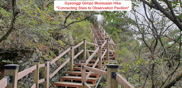
stair road connecting to Observation Pavilion where you could look down beautiful
Gangwha Island View. You could reach the Pavilion after about 5 minutes walking
on the stairs and take a short break and take and leave nice photo as attached.
This location is the junction joining from Munsusan Forest Recreation or from
Munsusan Namun Ridge Road which is stating as 800m to the Summit. I could now
see remote view of Munsusan Summit connecting with Fort Castle as see at
attached photo. When you walk on the ridge road for about 10 minutes more, you
could see Hongyemun (Gate) Junction where you could continuously walk to the
Summit straight or going to Military Base at right turn. I choose straight road
and walk for about 5 minutes and meet so clear view of Pavilion at Summit and
connecting fort castle so closely as see at the photo. I walked for about 5
minutes more and reach next junction saying as 100m to the Summit and continuously
go on walking for 10 minutes more and finally touch Munsusan Summit (379m
altitude) where I could look over North Korea Territory very closely, just
crossing the Han River about 200m or maximum 300m. I took a photo as well as
video covering the territory and around view at the Summit and enjoy delicious lunch pack for long
time. It is very simple and easy to return the Parking Lot 2 since I just take
reverse course on my way back.
If you like to overlook on video, Please link to https://www.youtube.com/watch?v=Y44ulGStbWs


댓글 없음:
댓글 쓰기